‘Snow Day’ Forecast: Blowing Snow Threat Friday May Give Some Southern Ontario Students an Early Start to March Break
/For an updated list of school bus cancellations & school closures, please visit our live article: https://instantweatherinc.com/article/2026/3/13/bus-cancellations

NOTE: Many school boards are off on Friday due to a PA Day. We do not factor PA Days into our forecast because they vary between regions, and even some school boards in the same region can have different PA Days. If you have a PA Day tomorrow, disregard this forecast and enjoy the guaranteed snow day.
NOTE: YOU CAN CLICK ON THE MAP TO OPEN A ZOOMABLE IMAGE
Widespread snow is expected to move across Southern Ontario beginning late Friday morning and continuing throughout much of the afternoon and evening. While this will not be a major snowstorm, the combination of steady snowfall and strong wind gusts may create some tricky travel conditions, especially in rural and exposed areas where blowing snow can quickly reduce visibility.
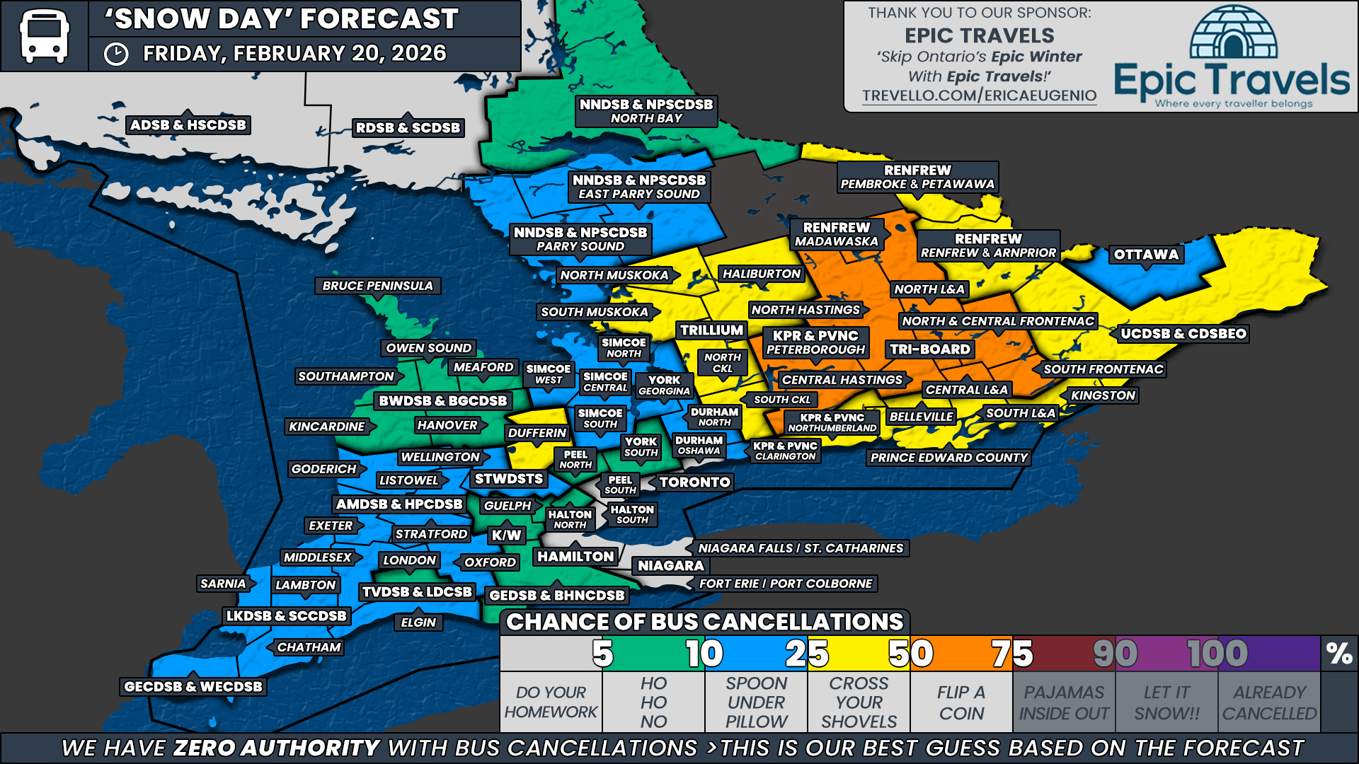
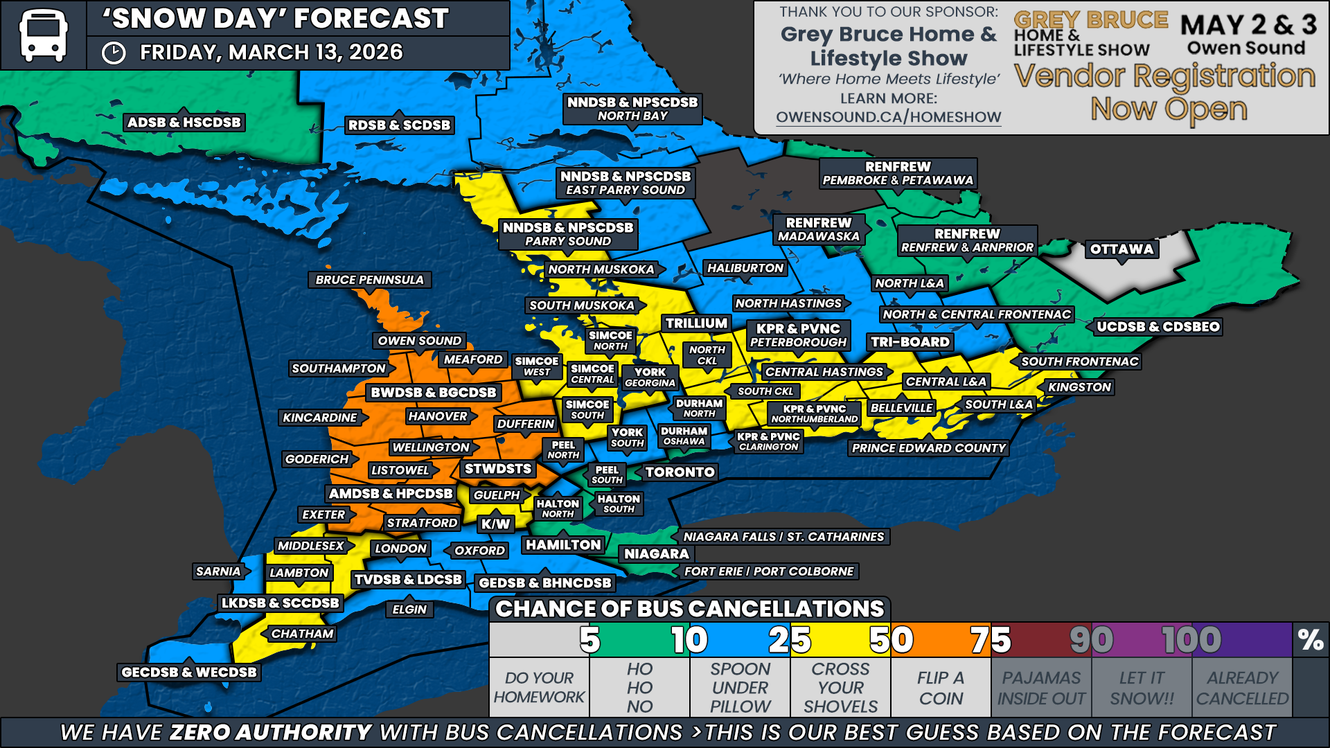
Current projections suggest snowfall totals will generally fall in the 10 to 15 centimetre range by the end of the day in the hardest hit regions. This amount of snow typically sits right near the threshold where school boards begin to consider cancelling buses. However, the biggest complication with this event is the timing.
Unlike snow events that arrive overnight or during the early morning hours, the snow with this system is not expected to begin in most regions until after school transportation decisions have already been made. In many communities, the snow will only just be starting or may not even begin until late morning or early afternoon. That means school boards would need to make proactive decisions based on expected afternoon travel conditions rather than the conditions they see early in the morning.
At this point, Environment Canada has issued a special weather statement for parts of the region rather than a snowfall warning or blowing snow advisory. Historically, many school boards are hesitant to cancel buses proactively when only a special weather statement is in place. That means there is a real possibility that some boards choose to run buses and hope conditions hold off until after the afternoon transportation runs.
If Environment Canada upgrades the alerts to a snowfall warning or blowing snow advisory by Friday morning, the probability of cancellations would increase significantly. Until that happens, the timing and messaging around this event keep the forecast a little more uncertain.
Because of that uncertainty, we have capped our highest probability at 50 percent for the regions most likely to experience poor travel conditions. These are areas that tend to be more rural, have a higher number of exposed routes, and are more vulnerable to blowing snow when winds increase during the afternoon.
The regions that currently sit in this toss-up category include all zones within the Bluewater District School Board, the Avon Maitland District School Board, and Wellington and Dufferin counties under the Upper Grand District School Board. These areas are expected to see some of the more persistent snowfall, along with gusty winds that could produce localized blowing snow. While we are leaning toward at least some cancellations in these regions, the late arrival of the snow keeps confidence from reaching the 75 or 90 percent category.
Beyond these areas, we have placed a wide swath of Southern Ontario in a slight chance category with a 25 percent probability of cancellations. This includes Chatham and Lambton counties under the Lambton Kent District School Board, Middlesex County under the Thames Valley District School Board, the Waterloo Region District School Board, Guelph under the Upper Grand District School Board, all weather zones within the Simcoe County District School Board, South Muskoka along with North and South Kawartha Lakes under the Trillium Lakelands District School Board, Parry Sound under the Near North District School Board, Peterborough and Northumberland counties under the Kawartha Pine Ridge District School Board, and Central Hastings, Belleville, Prince Edward County, Central and South Lennox and Addington, South Frontenac, and Kingston under Tri Board Student Transportation Services.
These areas may also see periods of blowing snow and reduced visibility through the day on Friday. However, we are leaning toward many of these school boards choosing to operate buses as normal because the snow will not arrive until later in the day for many of these regions. In Central and Eastern Ontario, especially, some boards may decide to roll the dice and hope the worst conditions develop after the afternoon bus run.
In Southwestern Ontario, the lower probability is due in part to some of these regions being more urban, such as Waterloo Region and Guelph, where the threshold for cancellations is typically higher. In other areas, the special weather statement does not specifically mention blowing snow, even though localized blowing snow is still possible with gusty winds.
Across the remainder of Southern Ontario, including northern portions of Central and Eastern Ontario and the Greater Toronto Area, a snow day on Friday appears unlikely. For the urban school boards around the Greater Toronto Area, the expected snowfall amounts are well below the threshold that usually prompts cancellations. Meanwhile, regions farther north and east are expected to see lighter totals overall, with the bulk of the snowfall occurring later Friday afternoon and evening, after the school day is already over.
This forecast comes with a higher-than-normal amount of uncertainty because of the timing of the snow. Many may look at snowfall totals of 10 to 15cm and expect a higher likelihood of cancellations. However, because most of the snow is expected after the morning decision window, the probability of cancellations is slightly lower than it might otherwise be.
Even so, a 25 percent or 50 percent chance is still notable and indicates that at least some regions could see buses cancelled depending on the proactivity of each school board or bus company.
Disclaimer: Instant Weather has zero authority when it comes to bus and school closures.
It is completely up to the school boards, bus companies, local authorities, and parents to decide what is best for their children. This is our best guess based on our forecast.