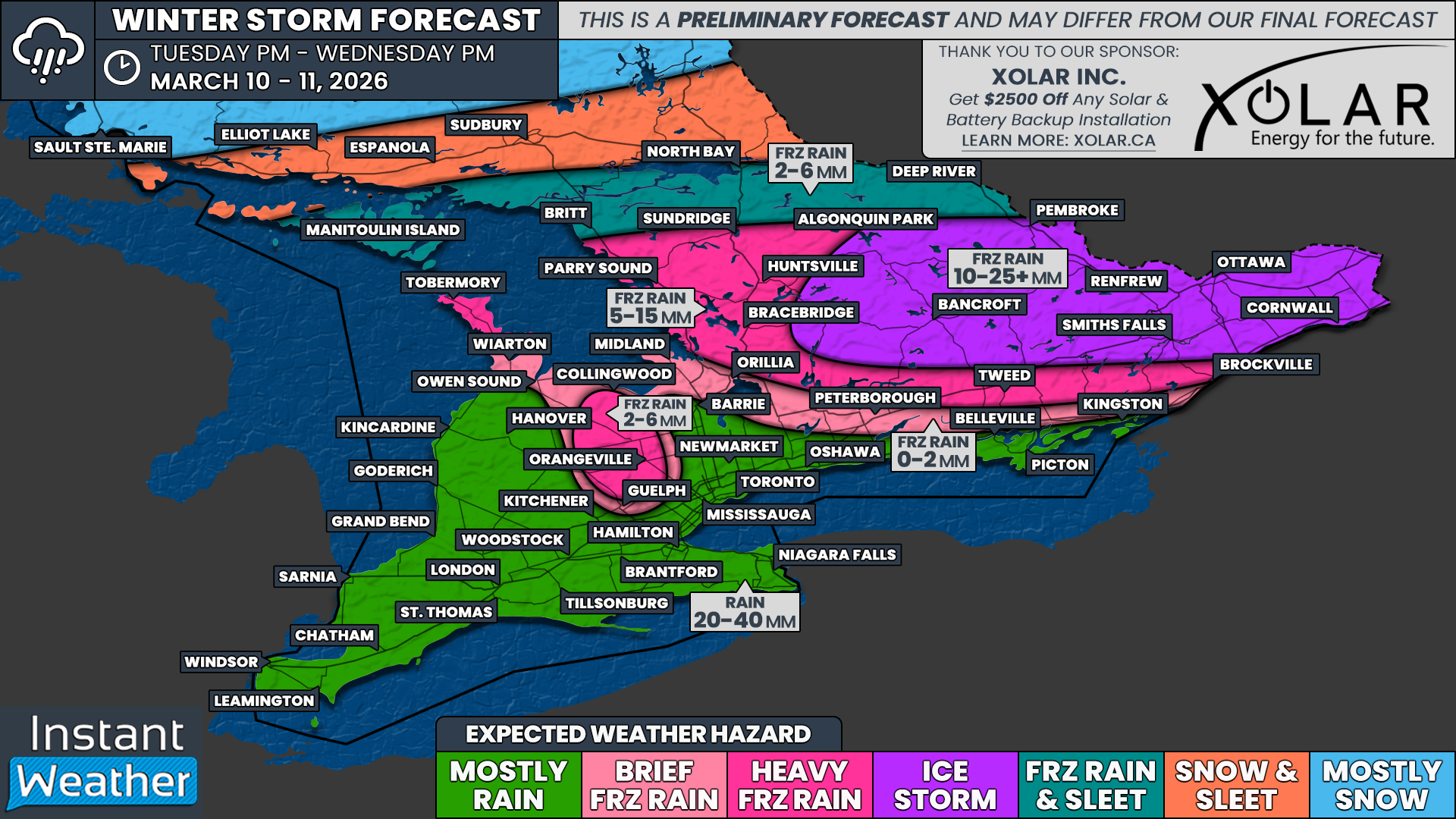
Major Ice Storm Targeting Ottawa Area Wednesday, Up to 25mm of Freezing Rain Threatens Power Outages Across Central and Eastern Ontario
/

NOTE: YOU CAN CLICK ON THE MAP TO OPEN A ZOOMABLE IMAGE
A complex weather story is set to unfold across Southern Ontario over the next 24 hours as cold and warm air clash across the region while a moisture-laden system moves through.
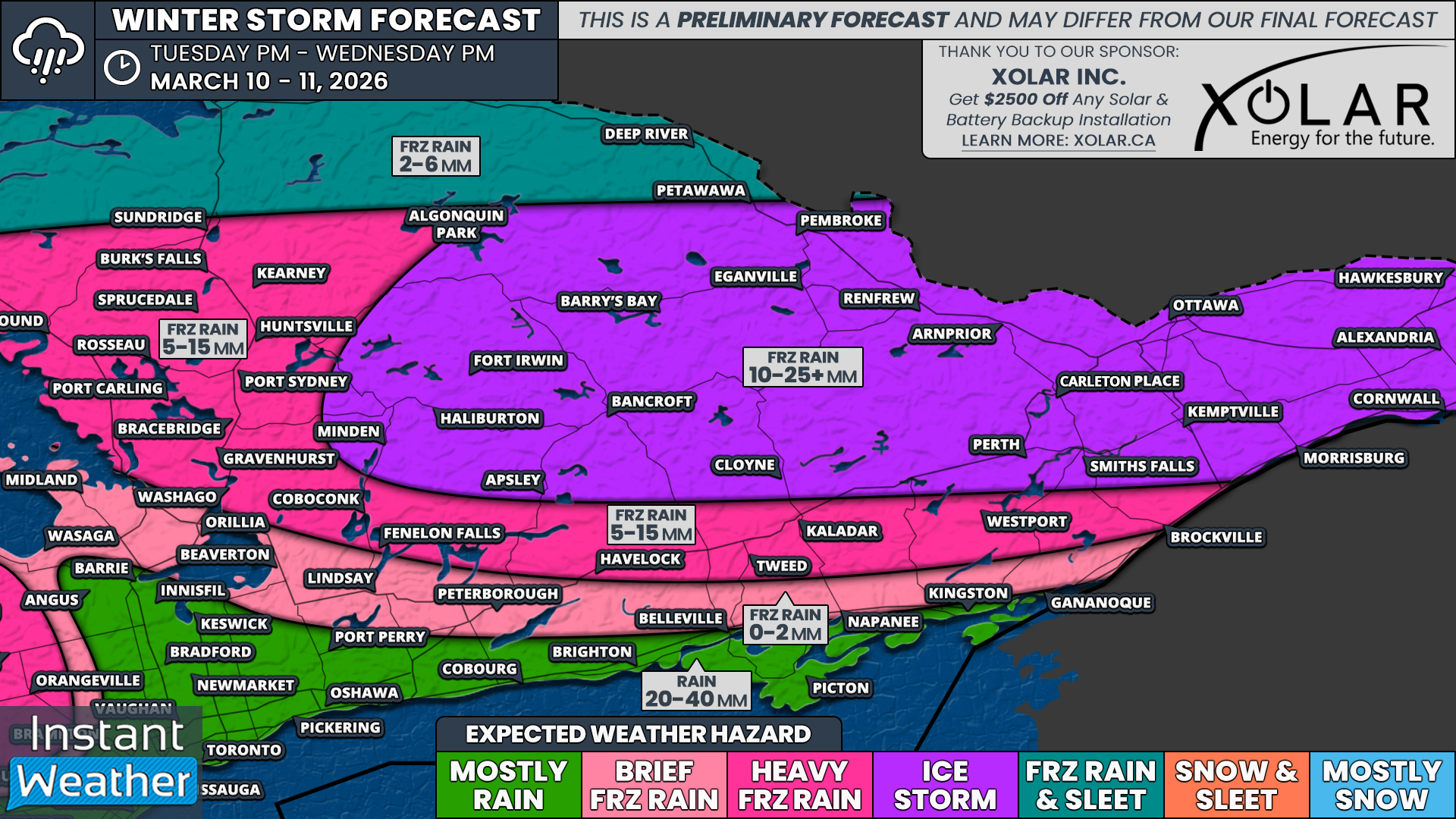
The biggest impact will come in the form of a concerning prolonged ice storm event across parts of Central and Eastern Ontario. In some areas, this freezing rain could be nearly non-stop for much of Wednesday, leading to up to 24 hours of persistent icing. The worst of the freezing rain is expected to begin overnight Tuesday and continue into Wednesday morning, with a second round arriving later in the day.
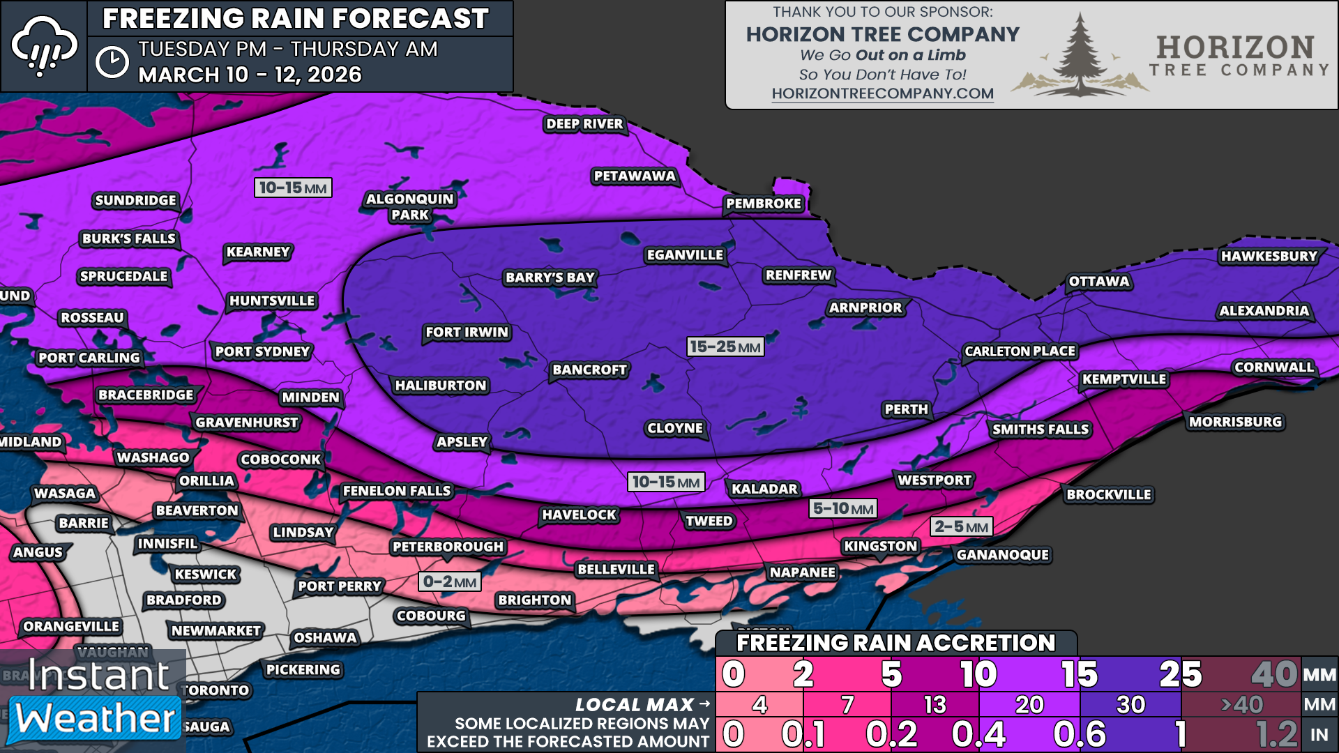
The Ottawa Valley and northern sections of Eastern and Central Ontario appear likely to take the brunt of the ice storm, with up to 15-25mm of ice accretion possible. That amount of ice is more than enough to cause substantial damage to infrastructure, raising the threat of widespread and potentially prolonged power outages that may last for days or even weeks.
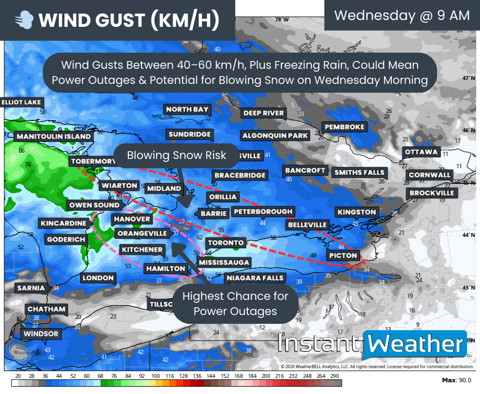
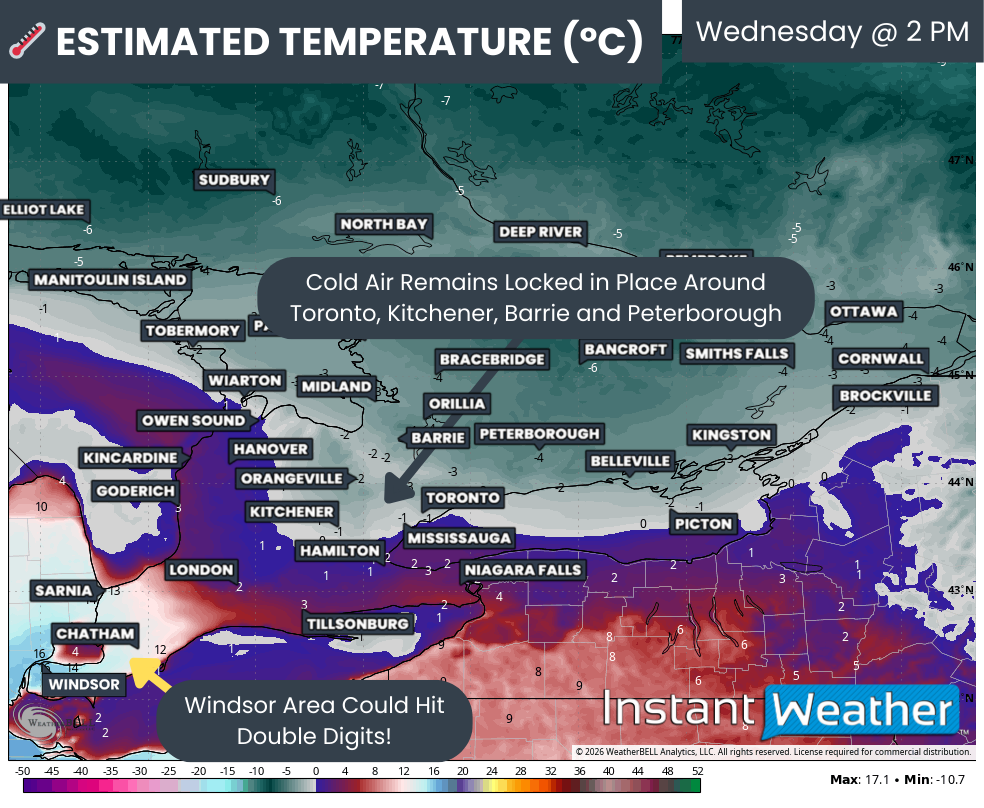
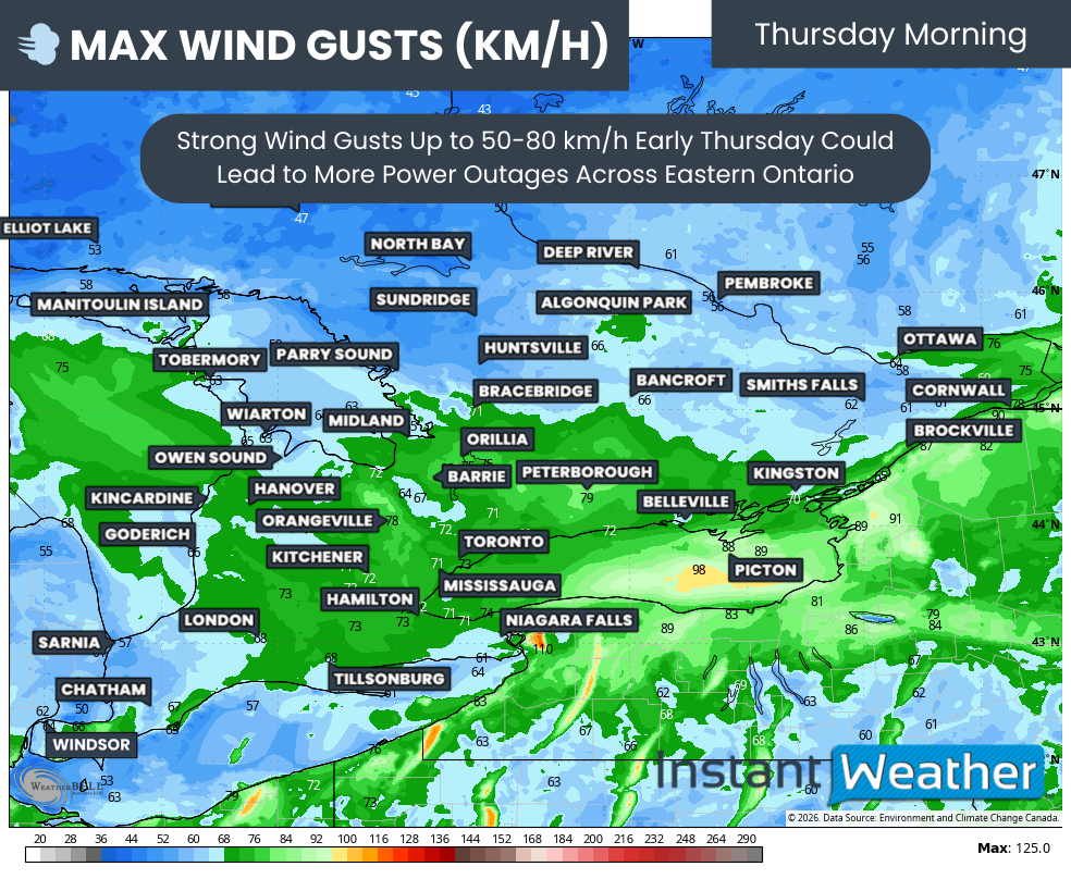
To make matters worse, some of those hardest hit areas may remain below freezing for the entire duration of the event before temperatures plunge even further late Wednesday as colder air floods in behind the system. This would lock in the ice accretion and allow it to continue weighing down trees and power lines for the foreseeable future. Stronger winds gusting in excess of 50 km/h early Thursday could add additional strain and prompt even more power outages.
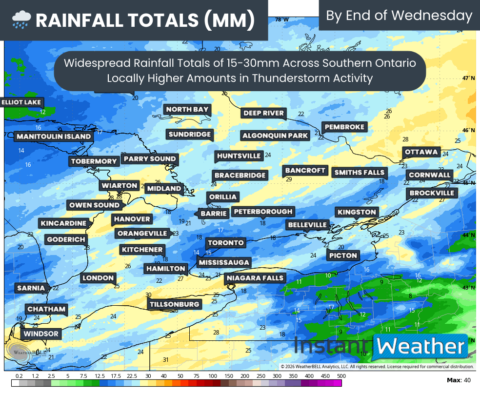
For other parts of Southern Ontario, the story will be some noisy nocturnal thunderstorms moving in early Wednesday morning from Michigan. While these storms should remain sub-severe for the most part, they could still produce strong wind gusts that may briefly reach marginally severe levels in a few pockets. Another concern is that this rain could further exacerbate the ongoing spring flooding that is already leading to higher water levels in many watersheds, with widespread 15–30mm of additional rainfall on tap.
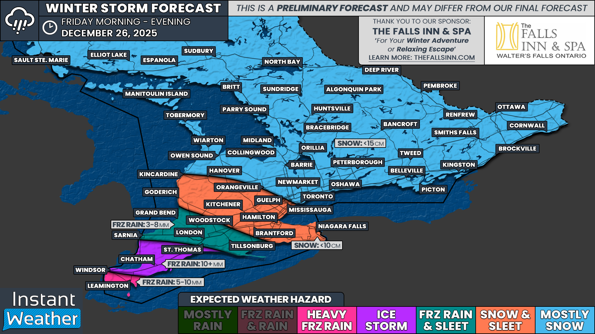
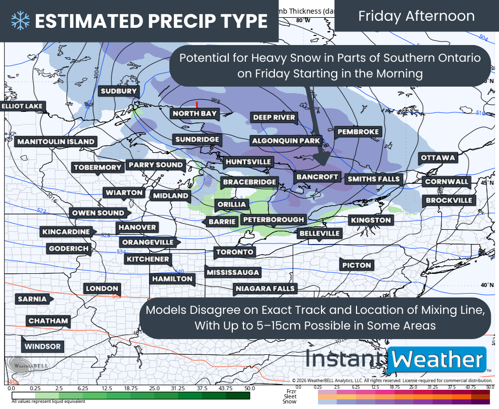
After this system moves out, we are set to enter a cooler and more active pattern beginning with a potential snowy system on Friday. Confidence remains fairly low in the exact setup, and some mixing could reduce snowfall totals, especially near the shorelines of Lake Ontario and Lake Huron. However, it could still deliver a widespread 5-15cm of snow, bringing back a snowy landscape that has been melted away in many areas over the past few days.
PRECIP TYPE - MAP FROM WEATHERBELL
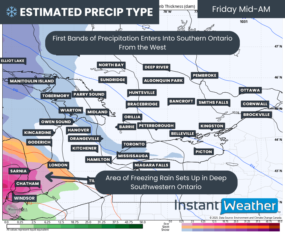
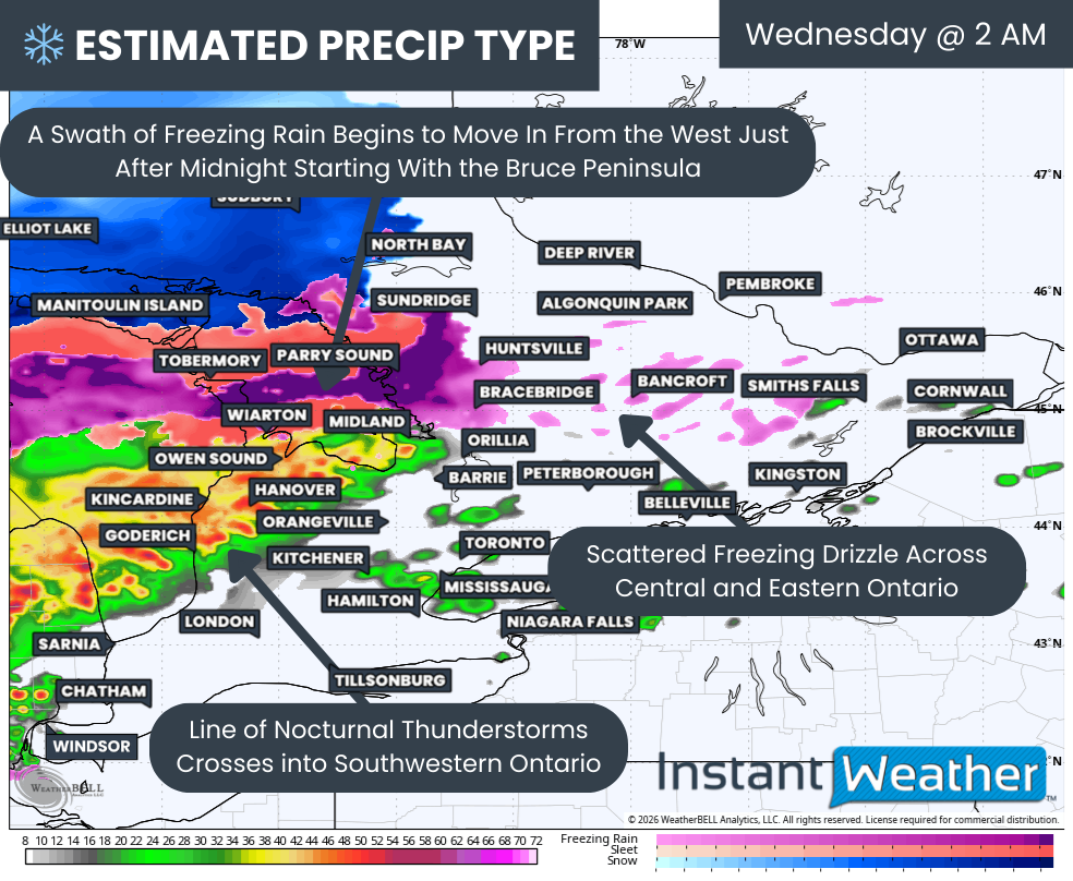
Current indications suggest the leading edge of the system will begin to move into Southwestern Ontario around or just after midnight. That will arrive in the form of heavy rain and embedded thunderstorms stretching across Lake Huron. These storms are actually part of a larger line that merged from earlier severe activity over Illinois and Indiana, where a severe weather outbreak is underway Tuesday evening.
However, by the time these storms reach our region, and especially given that they will need to travel over the cold waters of Lake Huron, we expect they will have weakened considerably by landfall.
There is still an outside chance that a few embedded cells could remain strong enough to produce a marginal wind threat, particularly around Windsor and Sarnia, but that scenario remains very questionable.
Regardless of their strength, these storms will likely wake many residents up overnight thanks to frequent lightning and very heavy downpours.
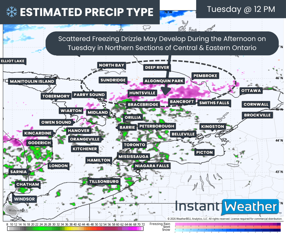
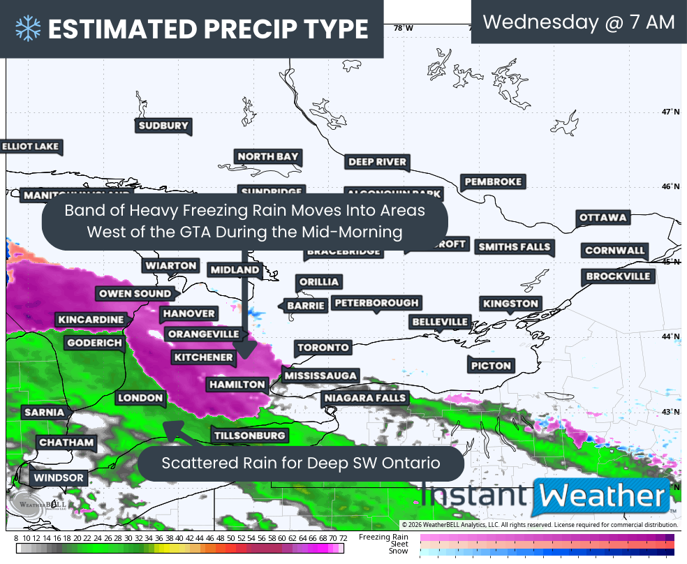
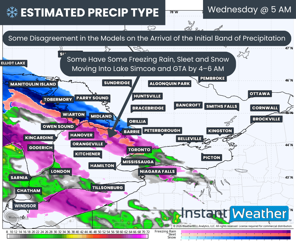
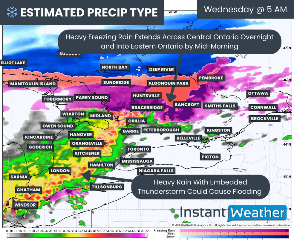
Further north, the system will encounter a pocket of below-freezing temperatures over the Bruce Peninsula. With warm air in place above the surface, this will allow a swath of freezing rain to develop starting over the Northern Bruce Peninsula and spreading eastward into areas east of Georgian Bay during the pre-dawn hours.
This icing could be quite heavy at times and may even feature some embedded lightning. Across the Sudbury and North Bay areas, precipitation should initially remain on the snow side with some ice pellets mixed in.
In advance of the system, we may also see some scattered freezing drizzle develop late Tuesday evening and continue into the overnight hours across parts of Central and Eastern Ontario.
PRECIP TYPE - MAP FROM WEATHERBELL
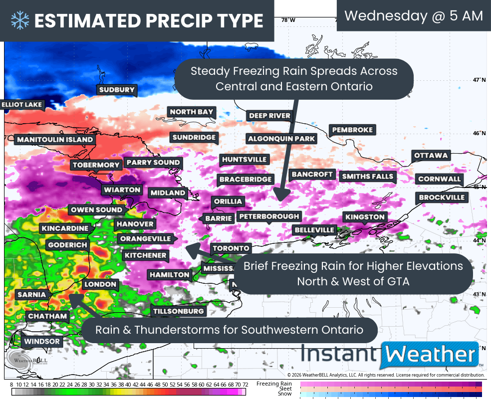
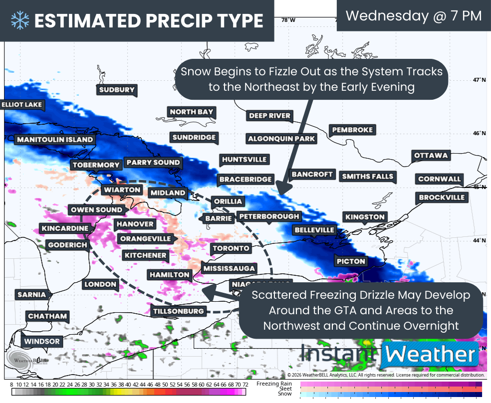
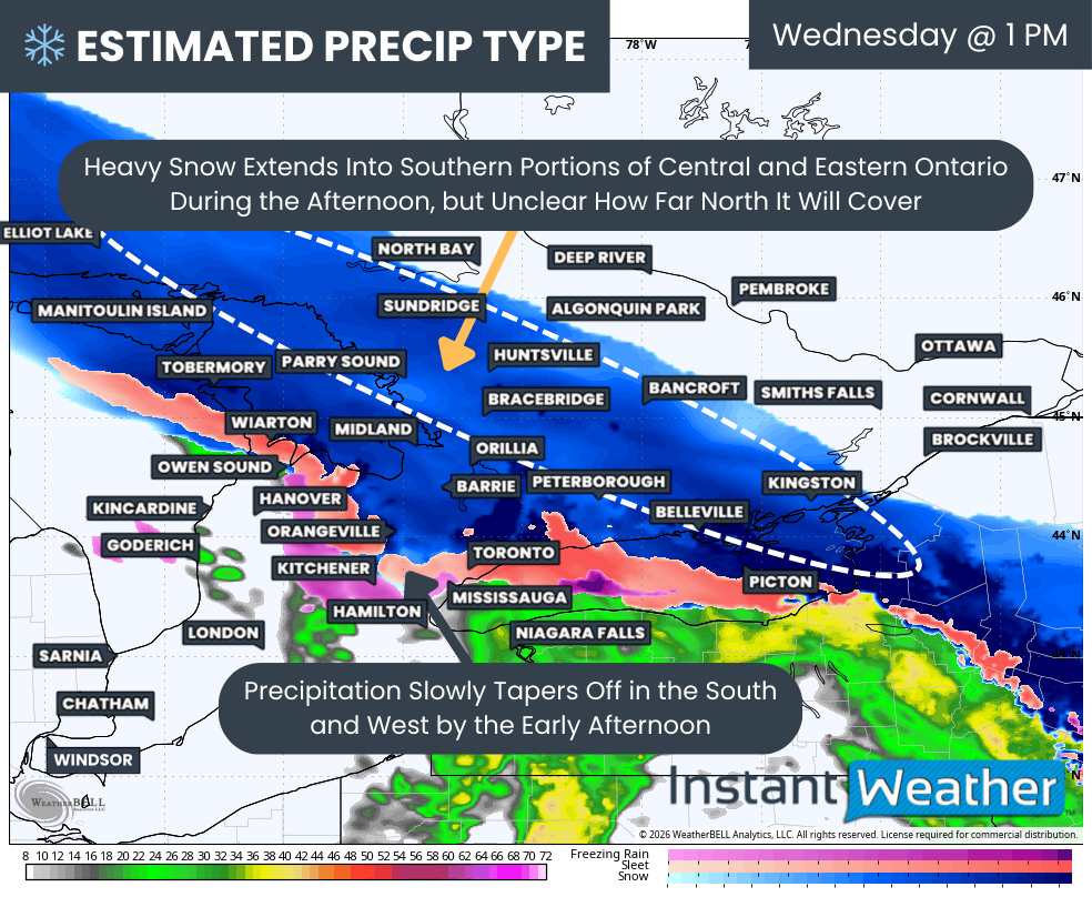
That swath of freezing rain will continue to progress eastward, with the freezing line roughly located from Bracebridge to Brockville.
Locations just to the south of this line, such as Midland, Orillia, Lindsay and Peterborough, may begin with some freezing rain, but precipitation should quickly transition over to rain as the warmer air advances northward through the mid-morning hours.
This setup will allow the most intense icing to occur from Parry Sound through Huntsville and into Bancroft just before sunrise. It should be noted that some northern sections, such as Algonquin Park, Pembroke and Sundridge, could remain just cold enough to keep some precipitation falling as ice pellets before reaching the ground. This would delay the onset of icing somewhat and reduce overall ice accretion in those locations.
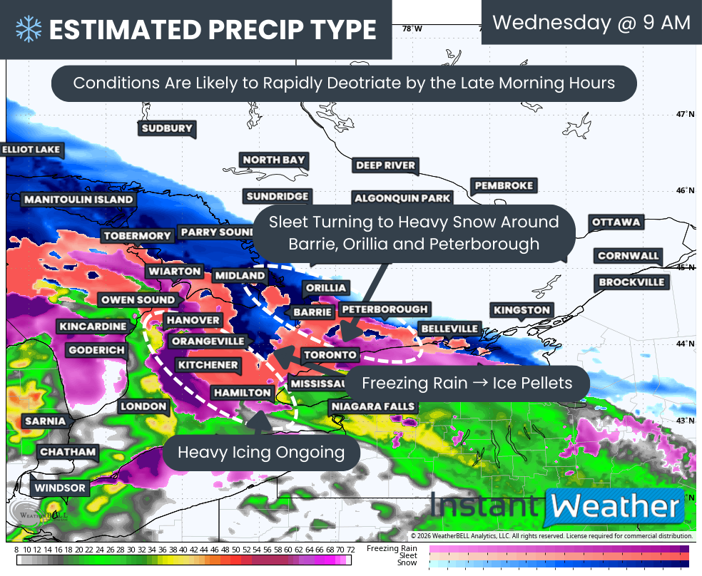
Meanwhile, the line of thunderstorms will continue tracking through Southwestern Ontario, slowly weakening as it approaches the Golden Horseshoe while still producing lightning and heavy rain. This rainfall could be quite intense at times and may lead to rapid accumulation, putting further strain on already saturated watersheds due to ongoing spring runoff. That could trigger additional flooding in some low-lying areas.
PRECIP TYPE - MAP FROM WEATHERBELL
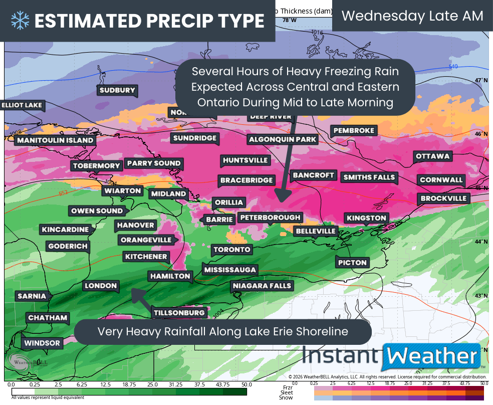
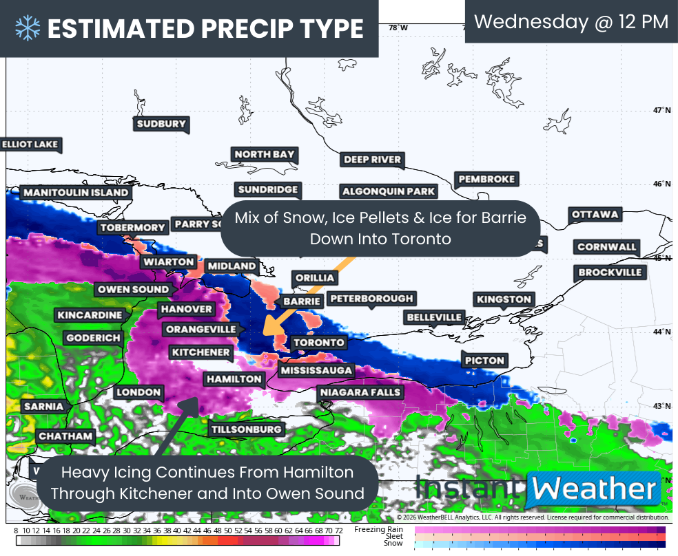
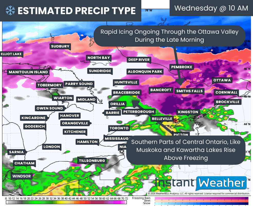
By mid-morning, the heavy freezing rain is expected to move into the Ottawa Valley, where it may persist through the late morning hours, bringing rapid ice accretion. Travel could quickly become treacherous for the morning commute in the Ottawa area, and within a few hours, the accumulating ice will likely begin taking a toll on the power grid.
We may also see the freezing rain line nudge northward into North Bay and Sudbury as warmer air aloft continues to expand northward despite the colder air at the surface remaining stubborn.
For the southern parts of Central Ontario, such as Bracebridge, Haliburton and Kawartha Lakes, it appears the warm air will eventually be able to overcome the cold air near the surface. This would allow these areas to escape the worst impacts, although they remain right on the line. If the cold air proves more stubborn than expected, it could keep these areas in freezing rain for several additional hours.
PRECIP TYPE - MAP FROM WEATHERBELL
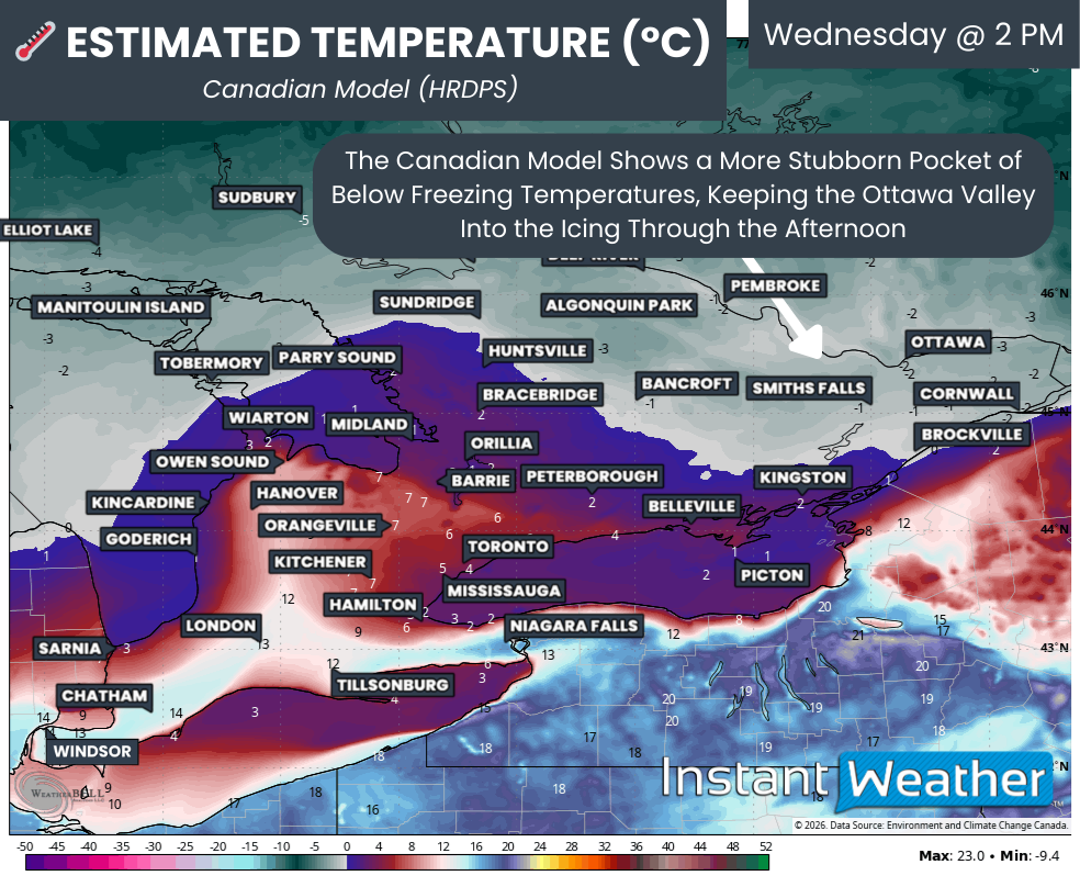
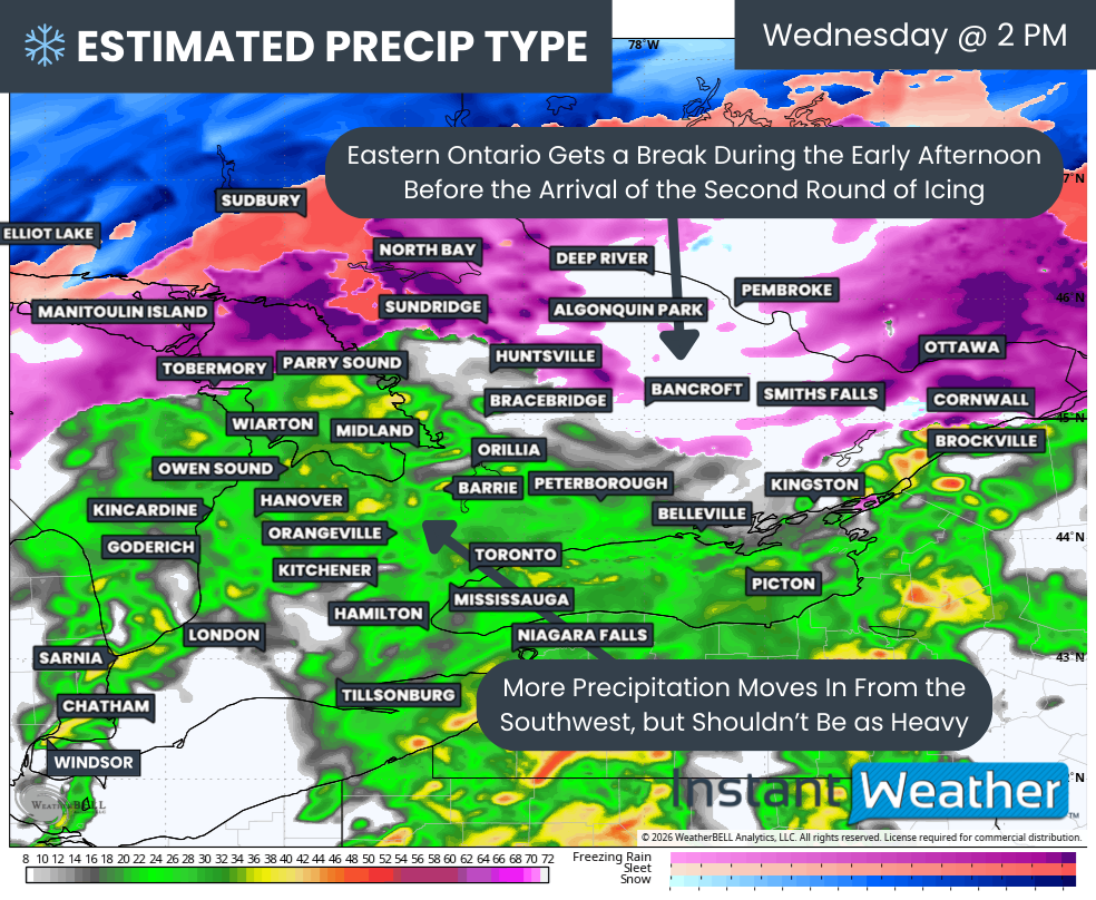
That will likely not be the case farther north across Central and Eastern Ontario, including much of the Ottawa Valley, where models suggest the freezing line will stall to the south.
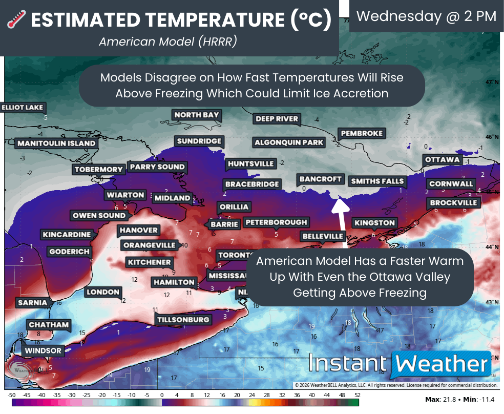
There remains some disagreement among the models regarding exactly how far north the warmer air will be able to advance. The best chance for temperatures to rise above freezing appears to be along the St. Lawrence River and southeast of Ottawa.
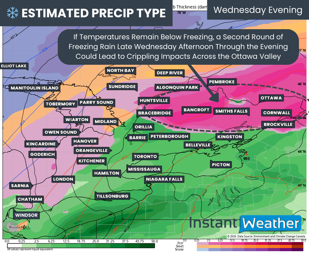
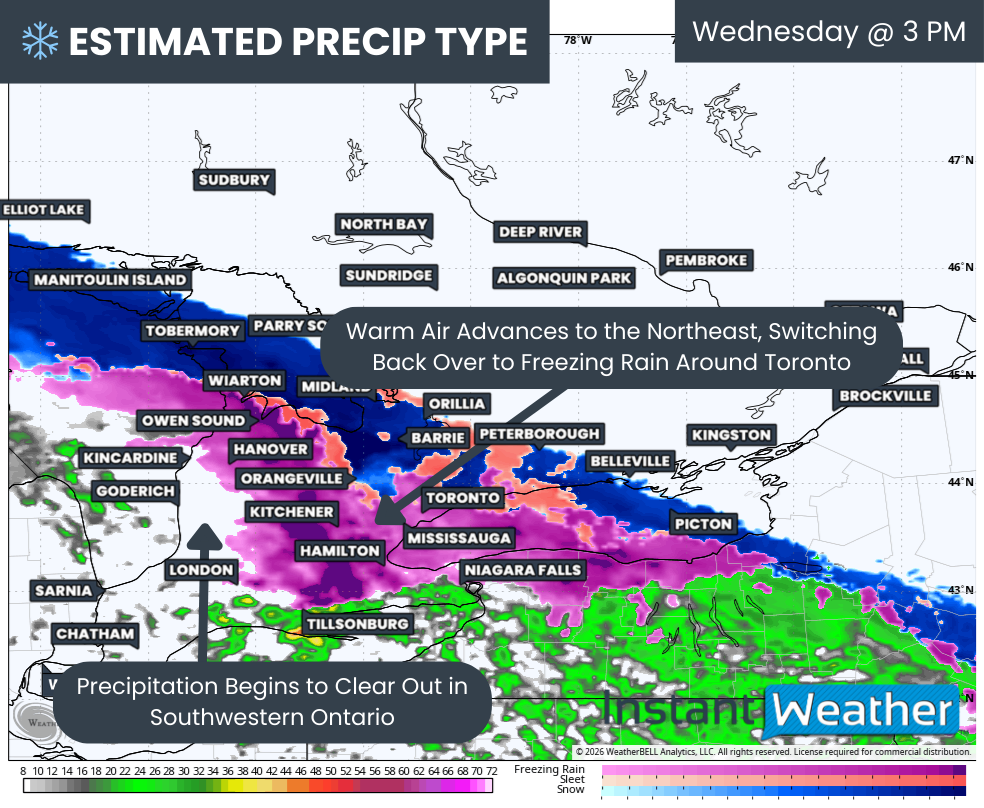
While precipitation should briefly lighten to drizzle by early afternoon as the first round moves into Quebec, additional steady precipitation will begin advancing from the southwest. This second round appears less intense than the first and will likely be light to moderate rather than a continuous downpour of freezing rain.
PRECIP TYPE - MAP FROM WEATHERBELL
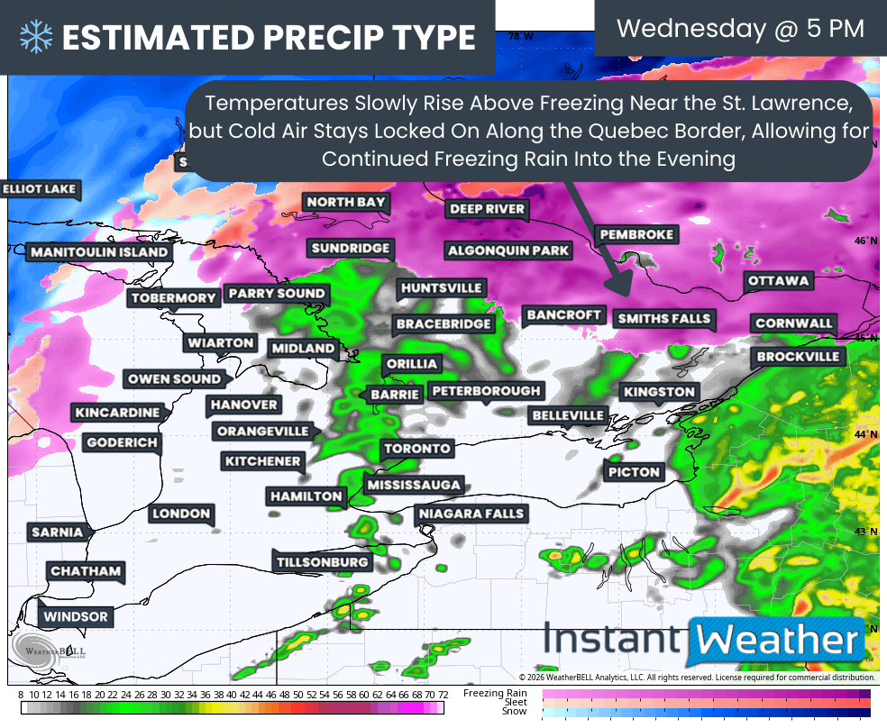
That precipitation should reach the Ottawa Valley by late Wednesday afternoon, with persistent freezing rain potentially continuing through the evening and into the early morning hours of Thursday. However, the precipitation should become more scattered after midnight, gradually tapering off to drizzle.
Some parts of the Ottawa Valley may briefly rise above freezing, particularly near the southern edge of the ice storm risk around Bancroft, Smiths Falls and Cornwall. If that occurs, it would reduce the overall impact in these areas, although the temperature gradient will be extremely tight.
NOTE: YOU CAN CLICK ON THE MAP TO OPEN A ZOOMABLE IMAGE

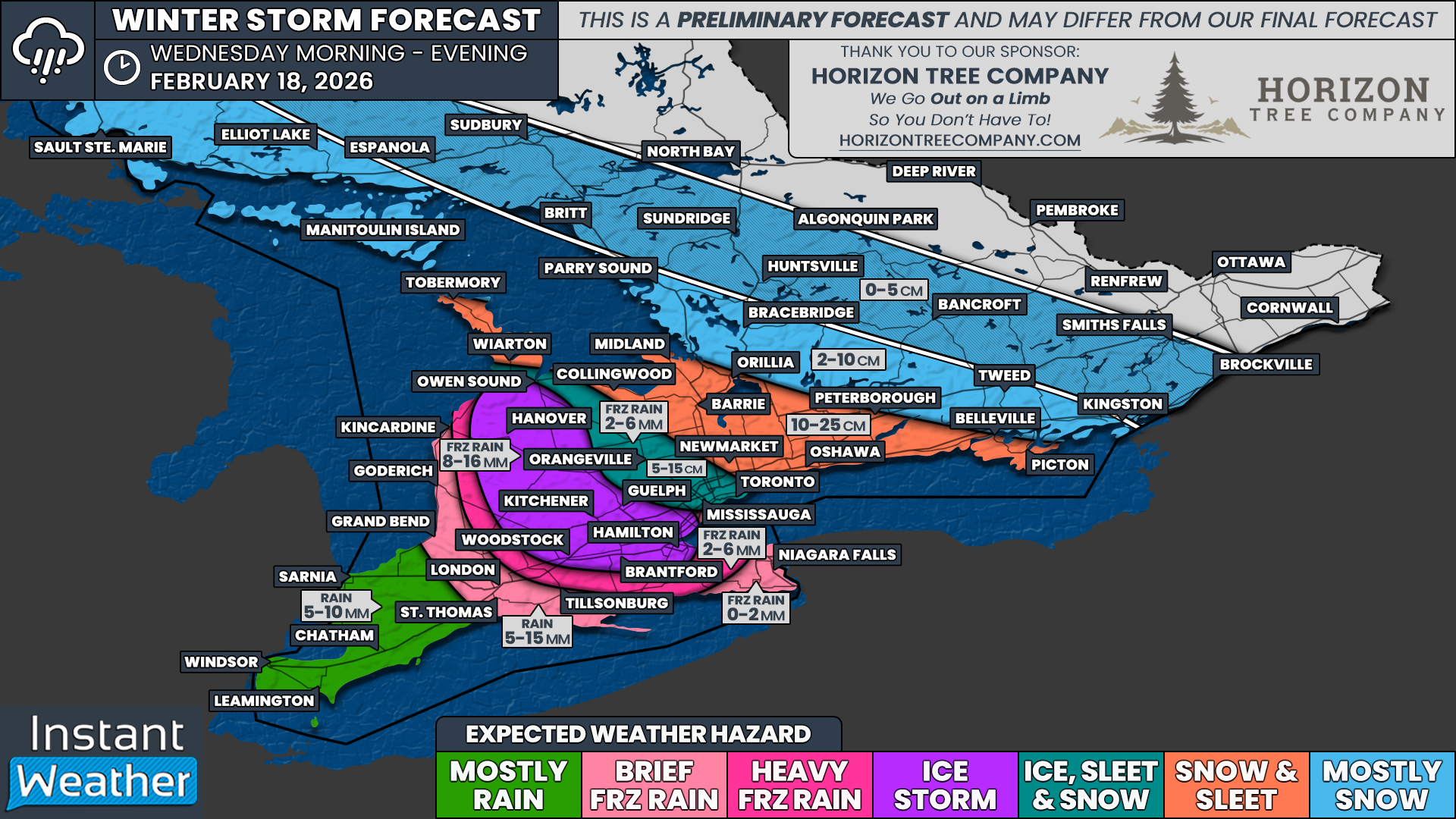
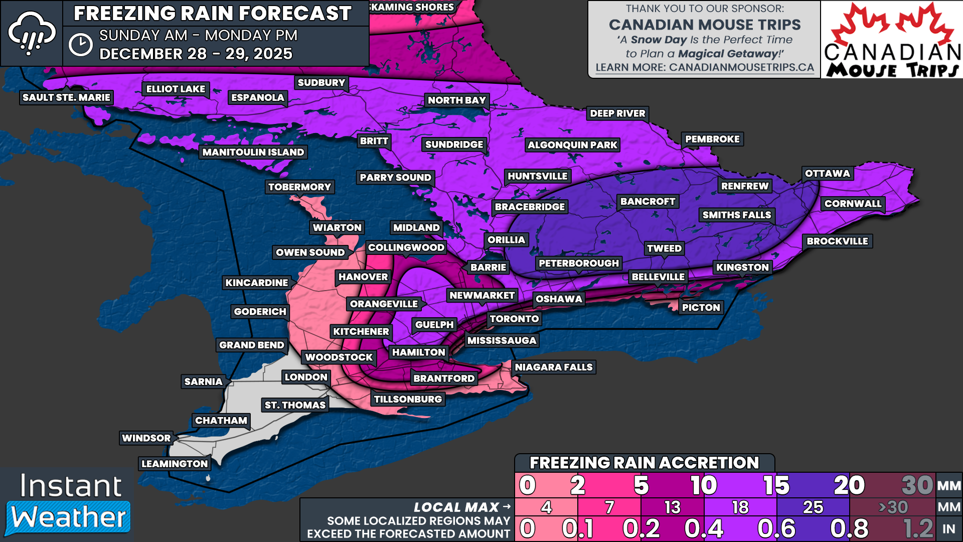
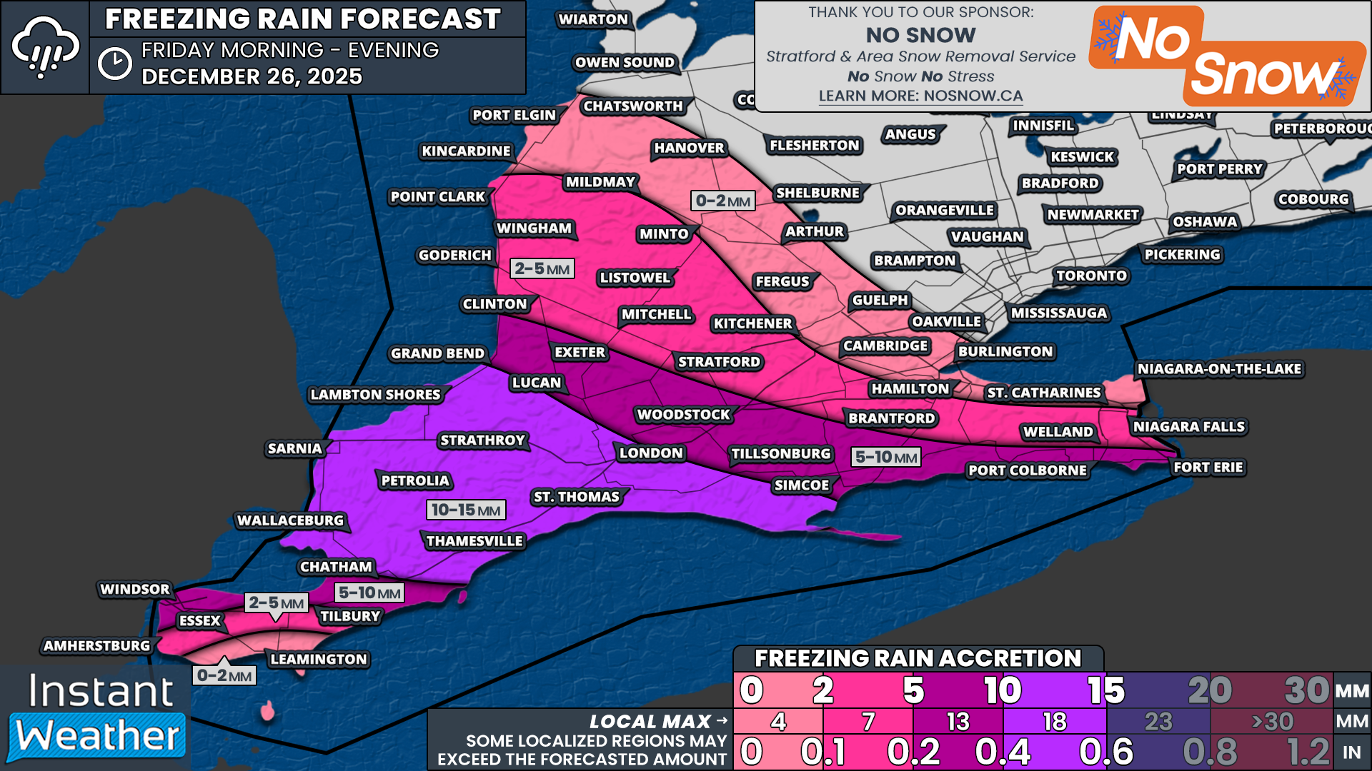
The hardest hit regions for freezing rain are expected to encompass a large portion of Eastern Ontario along the Quebec border and into the Ottawa Valley. In these areas, total ice accretion is likely to range from 15 to 25mm with localized amounts approaching 30mm.
That includes Ottawa, Hawkesbury, Alexandria, Carleton Place, Perth, Arnprior, Renfrew, Cloyne, Bancroft, Haliburton, Barry’s Bay and Pembroke.
However, keep in mind that actual surface accretion may end up somewhat lower since a large portion of the precipitation will fall during a short timeframe. Some of it may drip off surfaces before it has time to fully freeze when it arrives in heavy bursts.
Another major factor will be whether any areas are able to briefly climb above the freezing mark during the afternoon before the arrival of the second wave of precipitation. If that occurs, some of the earlier ice could melt away and make the second round far less efficient when it comes to additional ice accretion.
That is why this event could easily end up being far less damaging than currently forecast if temperatures trend just slightly warmer. There is often very little middle ground when it comes to ice storms, which is why there is such a tight gradient in our forecast ice totals.
Current projections suggest around 10-15mm of ice for northern sections of Central Ontario, including Parry Sound, Burk’s Falls, Huntsville, Algonquin Park and Deep River. This also extends into the Northern Bruce Peninsula. The slightly lower ice totals are due to temperatures potentially rising near Georgian Bay before the arrival of the second round of precipitation, along with the possibility of ice pellets mixing in farther north.
A similar situation may occur just south of the core ice storm zone, including Apsley, Kaladar, Smiths Falls, Kemptville and Cornwall. We expect the freezing line to eventually reach these areas by the afternoon, shutting off the freezing rain threat and substantially limiting the overall impact compared to locations farther north.
Further south, we are expecting around 5-10mm of ice from Bracebridge through Havelock, Tweed and into Morrisburg. Again, these areas should eventually rise above freezing, which will limit the impact mainly to the morning hours when icing is most persistent.
Across the Midland and Gravenhurst to Fenelon Falls corridor extending eastward toward Brockville, freezing rain should be more brief, primarily during the morning hours, leading to roughly 2-5mm of icing at most. We may also see around 2mm of icing in the higher elevations of the Dundalk Highlands, including Orangeville and Shelburne and extending into the Blue Mountains, although it remains uncertain if temperatures will be cold enough here for significant icing.
Very little icing is expected once you reach Lake Simcoe and areas stretching toward Kingston along the Lake Ontario shoreline. This includes Orillia, Lindsay, Peterborough and Belleville. There may be a brief one to two-hour window of freezing rain early in the morning, but temperatures should quickly rise above freezing. Less than 2mm of ice accretion is expected.
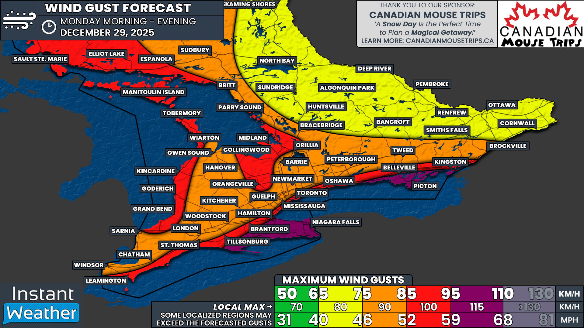
max wind gusts (km/h) - MAP FROM WEATHERBELL
While the freezing rain should taper off overnight Wednesday, the impacts may continue into Thursday in areas where earlier ice accretion remains locked in place as temperatures drop once again overnight. Ice-covered trees and power lines will remain vulnerable to wind due to the additional weight from the ice.
Unfortunately, stronger wind gusts could develop early Thursday morning with gusts potentially reaching 60-80 km/h in parts of Eastern Ontario. If significant ice remains in place, that would be a recipe for substantial damage to the power grid.
It also does not appear that the ice will be melting anytime soon. The pattern into next week looks to feature mostly below freezing temperatures across Eastern Ontario with wind chills dropping into the negative teens. That could make for dangerous conditions if widespread power outages occur and many homes are left without heat.
rainfall totals (mm) - MAP FROM WEATHERBELL
As for rainfall totals, we are expecting generally around 15-30mm across Southwestern Ontario and into the Golden Horseshoe. Localized pockets could see up to 50mm thanks to persistent thunderstorm activity, particularly along the Lake Erie shoreline.
PRECIP TYPE - MAP FROM WEATHERBELL
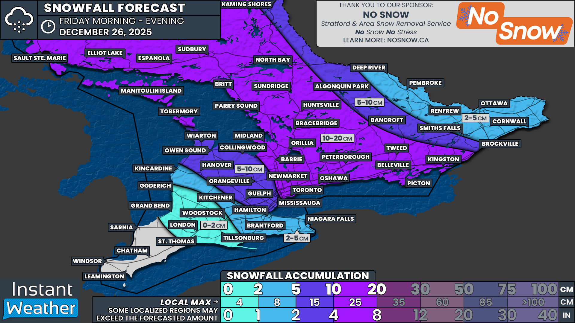
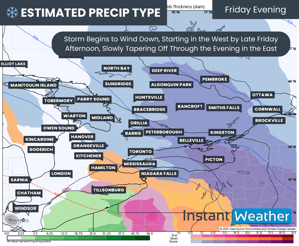
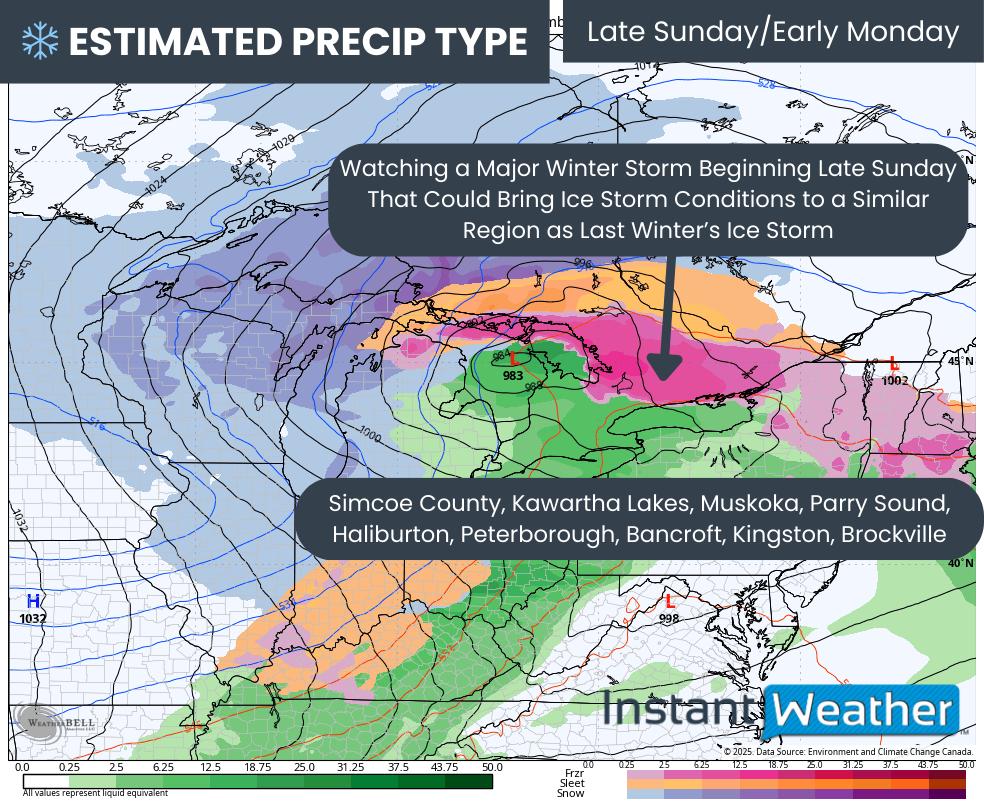
Looking ahead to Friday, we are also monitoring a potential widespread snowfall event across much of Southern Ontario.
There is still considerable uncertainty regarding who may see the heaviest snowfall due to the potential for rain mixing in depending on the exact track of the system. However, current indications suggest the heaviest snow could fall across Central and Eastern Ontario, where up to 5-15cm may accumulate throughout the day on Friday.
With Eastern Ontario likely still recovering from the ice storm, that snowfall could add even more weight to already weakened trees and infrastructure. This may lead to another round of falling branches and potentially additional power outages.
More details on Friday’s system will be provided in a separate forecast later this week.