Blowing Snow and Near-Blizzard Conditions Could Threaten Friday Evening Commute Across Southern Ontario
/
NOTE: YOU CAN CLICK ON THE MAP TO OPEN A ZOOMABLE IMAGE
This week has mostly offered a much-needed reprieve from what felt like an endless onslaught of snow that dominated much of January. For many across Southern Ontario, it finally felt like winter eased up a little. Aside from an Alberta Clipper earlier this week, snowfall became lighter and more scattered, and we even managed to climb out of the deep freeze over the past few days, with temperatures returning closer to seasonal norms for early February.
That quieter stretch is now coming to an end as we head into the weekend. A fast-moving but potent weather system is set to cross the region on Friday, bringing a quick blast of heavy snow, strong winds, and sharply falling temperatures. While this will not be a long-duration storm, its timing and intensity could still cause significant disruption.
The main feature to watch will be a cold front sweeping across Ontario on Friday afternoon and evening. Along the leading edge of this front, a frontal squall is expected to develop. This type of setup is known for producing intense snowfall over a very short period of time, often accompanied by rapidly worsening visibility.
As this squall moves through, whiteout conditions are likely to develop with little warning. Snowfall rates could become very heavy for one to two hours in many areas, which is more than enough time for roads to become snow-covered and slippery before plows are able to respond.
Wind will be another major factor with this system. In the wake of the cold front, wind gusts are expected to ramp up quickly. Many areas could see gusts exceeding 70 km/h, with even stronger gusts possible in some locations. This combination of fresh snow and strong winds will lead to widespread blowing snow and significantly reduced visibility.
Unfortunately, the worst of these conditions is expected to line up with the afternoon and early evening commute across much of Southwestern and Central Ontario. Travel conditions could deteriorate rapidly during this window, especially on highways and open rural roads where blowing snow tends to be more severe.
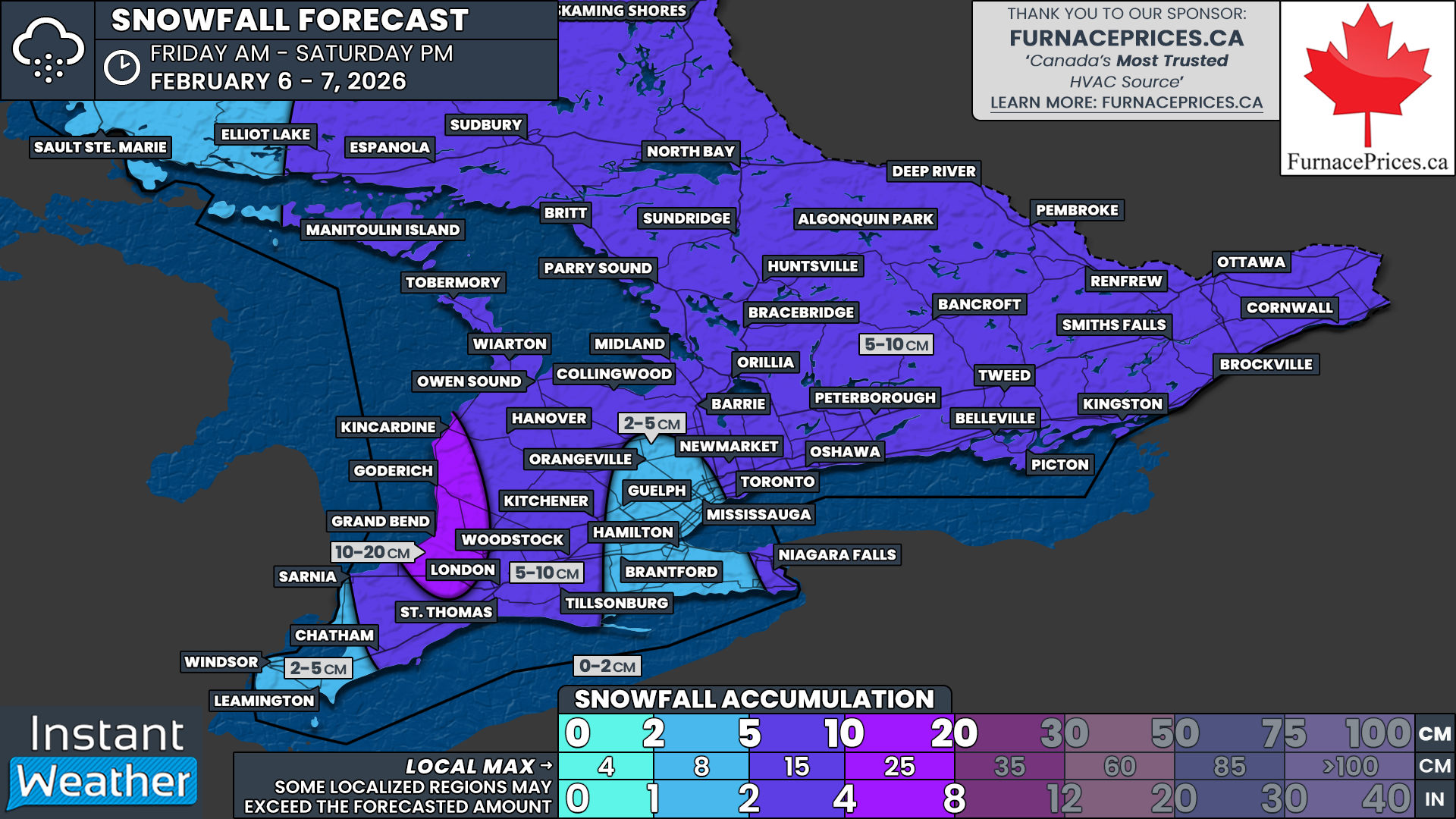
Snowfall totals from this system are not expected to be extreme by winter standards. Most areas are generally looking at around 5 to 10 cm of snow, with locally higher amounts possible. Areas near Lake Huron could see totals exceed 10 cm due to minor lake enhancement adding to the frontal snow.
The bigger concern is not how much snow falls, but how quickly it falls. With most of the accumulation occurring in a narrow one to two-hour window, roads can become snow-covered very quickly. This rapid accumulation often leads to poor driving conditions even when overall totals are modest.
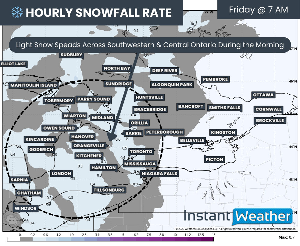
Hourly snowfall rates (cm) - MAP FROM WEATHERBELL
Snow is expected to begin spreading into Southwestern and Central Ontario during the mid-morning hours on Friday. At this point, winds should still be relatively light. Snowfall rates during the morning should generally remain below 1 cm per hour, which means conditions should stay manageable for the early part of the day.
This initial area of light snow will gradually expand eastward through the late morning and early afternoon, reaching Eastern Ontario as the day goes on. Travel impacts during this phase are expected to be limited, though roads may start to become slick in spots.

PRECIP TYPE - MAP FROM WEATHERBELL
By mid to late afternoon, attention turns to the arrival of the sharp cold front. This front will have three main impacts on the region, with the first being the intense frontal squall along its leading edge.
The squall is expected to begin moving into parts of Northern Ontario and the Lake Huron region sometime between 2 and 4 PM. From there, it will push steadily southeastward through the afternoon.
The Muskoka to London corridor is likely to see the squall move through between roughly 4 and 6 PM. During this time, snowfall rates could become very heavy, and visibility may drop to near zero for brief periods.
As the squall continues southeast, it is expected to reach the Greater Toronto Area around the dinner hour. While it may weaken somewhat by this point, a burst of heavy snow and gusty winds is still possible.
By the early evening, the squall should be pushing into Eastern Ontario, reaching areas such as Kingston and Ottawa sometime around 9 to 10 PM. Even though it will be later in the day, conditions could still become hazardous for a time as it moves through.
Whiteout conditions may occur with little warning wherever the squall passes. These conditions could last for an hour or two in any given location, making travel very difficult during that brief window.
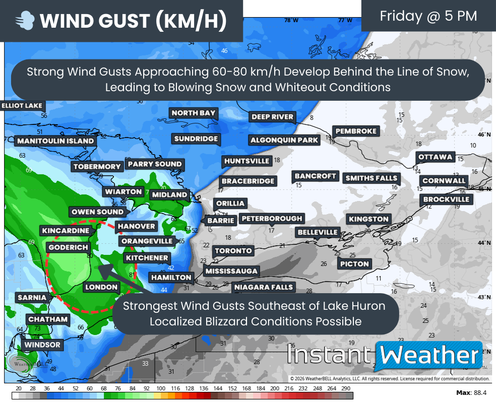
WIND GUST - MAP FROM WEATHERBELL
The second major concern with this system will be the strong winds developing behind the cold front. Wind gusts are expected to be strongest near Lake Huron, where some models are indicating gusts approaching 80 km/h from Goderich through Grand Bend and into London.
In this area, localized blizzard conditions are possible from the late afternoon into the evening hours. Environment Canada has mentioned that a blizzard warning may be required for parts of this region, though there remains some uncertainty regarding how long the strongest winds will last.
Even outside of the Lake Huron shoreline, many areas could see wind gusts between 50 and 70 km/h. These winds will be more than enough to cause blowing snow, especially with freshly fallen snow being easily lofted off the ground.
Blowing snow is likely to continue into the evening even after snowfall tapers off, prolonging travel impacts and keeping visibility reduced for several hours.
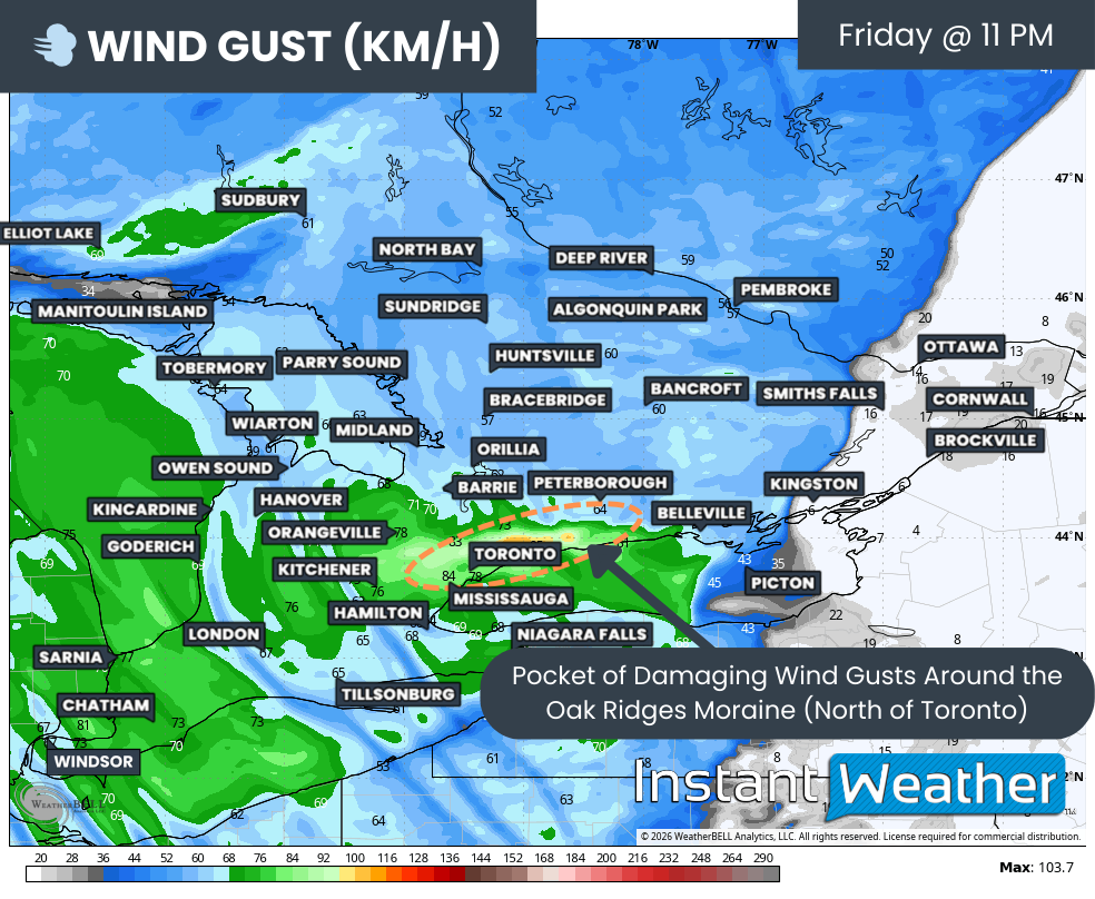
WIND GUST - MAP FROM WEATHERBELL
Another aspect being closely monitored is the potential for very strong wind gusts along higher elevations north of the Greater Toronto Area. Some models suggest a corridor of stronger winds following the Oak Ridges Moraine, extending from Durham Region through York Region and into parts of Peel Region.
In these areas, wind gusts could approach or even exceed 90 km/h. If this scenario materializes, there could be an increased risk of power outages and localized damage, especially in exposed areas.
Hourly snowfall rates (cm) - MAP FROM WEATHERBELL
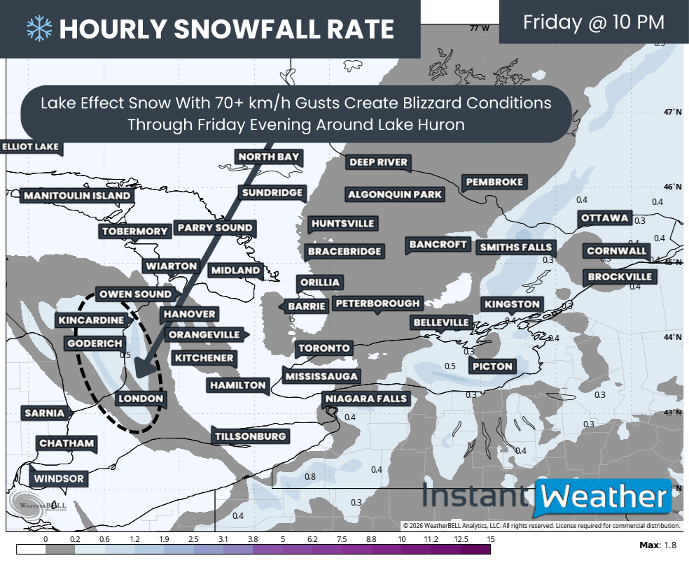
Behind the cold front, lake effect snow is expected to develop along the Lake Huron shoreline Friday evening and continue overnight. The exact intensity of this lake effect snow remains somewhat uncertain.
A significant portion of Lake Huron is currently covered in ice, which can limit how much moisture the lake can supply. This may prevent the lake effect from becoming as intense as it otherwise could be.
However, the very strong winds will play a major role in impacts regardless of snowfall intensity. Wind gusts exceeding 70 km/h will likely lead to near blizzard conditions along the shoreline, with blowing snow continuing through the evening and into the overnight hours.
WIND CHILL - MAP FROM WEATHERBELL
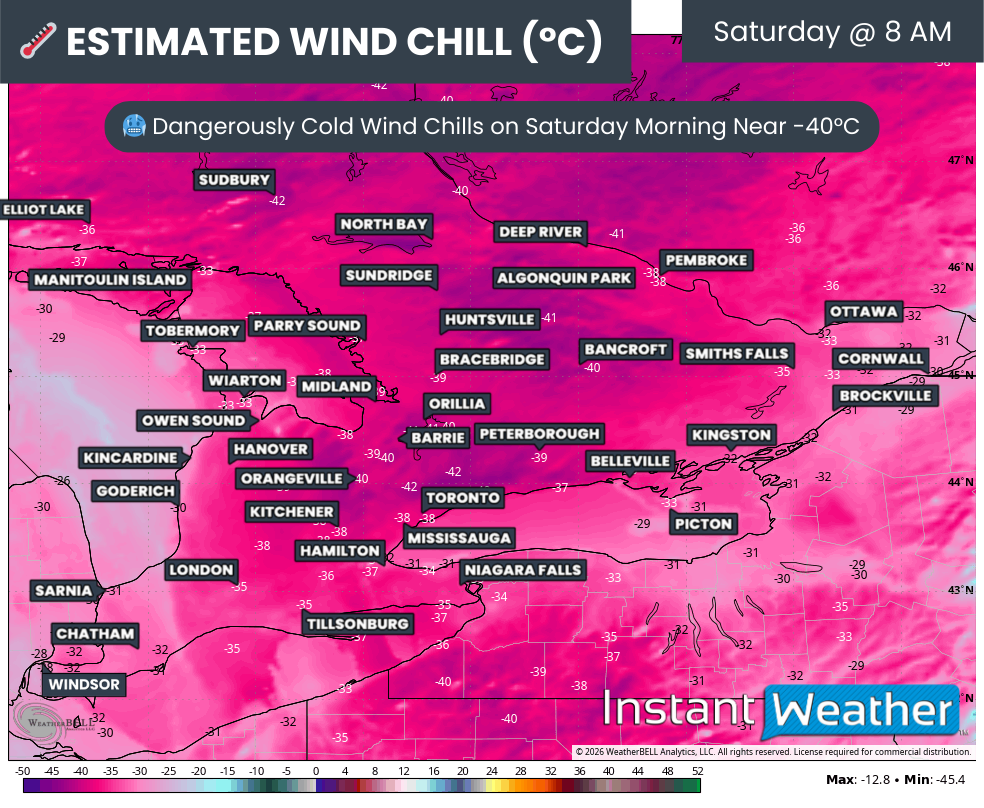
The third and perhaps most noticeable impact of this cold front will be the sudden return to bitterly cold temperatures. This drop in temperature will be sharp and abrupt, not gradual.
By Saturday morning, widespread wind chills are expected to make it feel well into the -30s across much of Southern Ontario. Some areas could even approach wind chills near -40°C.
Actual air temperatures are expected to range from -25°C to -30°C across most regions. Deep Southwestern Ontario, including areas closer to Lake Erie, may stay a bit milder, closer to -20°C.
NOTE: YOU CAN CLICK ON THE MAP TO OPEN A ZOOMABLE IMAGE

As mentioned, snowfall totals from this event are not expected to be overly impressive on their own and would be considered fairly typical for this time of year. The real story will be the wind, the rapid snowfall rates, and the extreme cold that follows.
The highest snowfall totals are expected along the Lake Huron shoreline from Kincardine down through Grand Bend. In these areas, 5 to 10 cm from the frontal squall combined with locally 10 to 15 cm from lake effect snow could result in overall totals between 10 and 20 cm.
Elsewhere across Southwestern Ontario, excluding Deep Southwestern Ontario, as well as Central and Eastern Ontario, a general 5 to 10 cm of snow is expected. Localized pockets could approach 15 cm if the squall slows down or briefly stalls over an area.
For Deep Southwestern Ontario, including Sarnia and Windsor, along with the western portions of the GTA and the Niagara region, snowfall totals are expected to be lower. Around 2 to 5 cm is likely in these areas as the frontal squall weakens and becomes less organized.
Even in areas with lower snowfall totals, conditions could still become hazardous for a time due to strong winds, blowing snow, and rapidly falling temperatures as winter reminds us it is far from finished.