Say It Ain’t Snow! Parts of Ontario and Quebec Could See Their First October Snowflakes Monday
/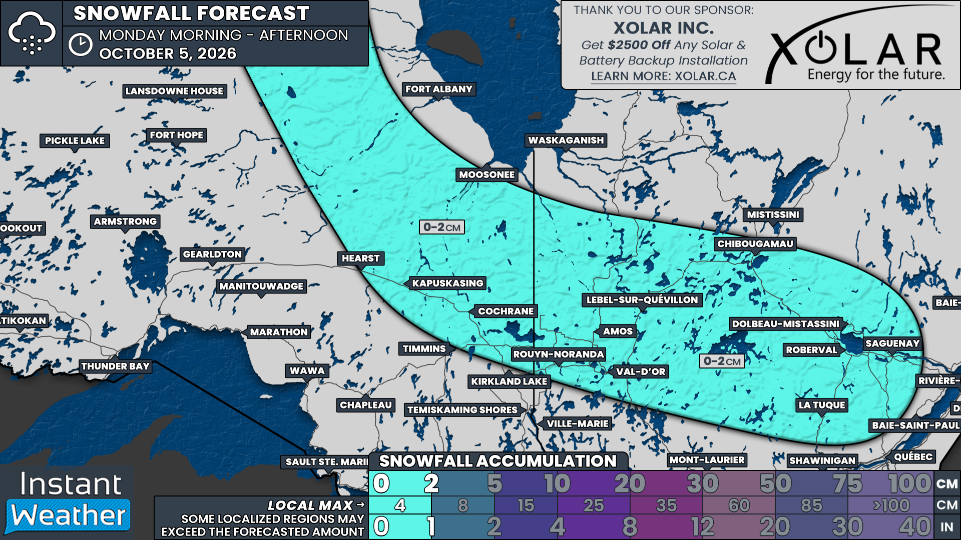
NOTE: YOU CAN CLICK ON THE MAP TO OPEN A ZOOMABLE IMAGE

Say it ain’t snow! As the leaves change across Ontario and the feeling of pumpkin spice season sets in, it was only a matter of time before some early-season snowflakes made an appearance.
And it appears that time has arrived for portions of Northeastern Ontario as we begin the first full week of October. A departing system near Hudson Bay and James Bay is expected to usher in near-freezing temperatures overnight Sunday, October 4, into Monday, October 5, allowing rain to mix with or transition to wet snow.
That snow potential will also extend into portions of Western and Central Quebec as the colder air spreads eastward through Monday morning and early afternoon.
The good news is that, like many early-season snowfalls, temperatures are expected to hover slightly above freezing. Combined with the relatively warm ground, this should limit accumulation. Any snow that does manage to stick should melt quickly as temperatures rise later in the day.
Locations including Hearst, Kapuskasing, Cochrane and Timmins could see a few wet flakes early Monday morning. Moosonee also has a chance of seeing snow, although warmer air near James Bay could keep precipitation falling as rain.
In Quebec, locations that could see wet snow include Rouyn-Noranda, Amos, Lebel-sur-Quévillon, Val-d’Or, Chibougamau, Dolbeau-Mistassini, La Tuque and Saguenay.
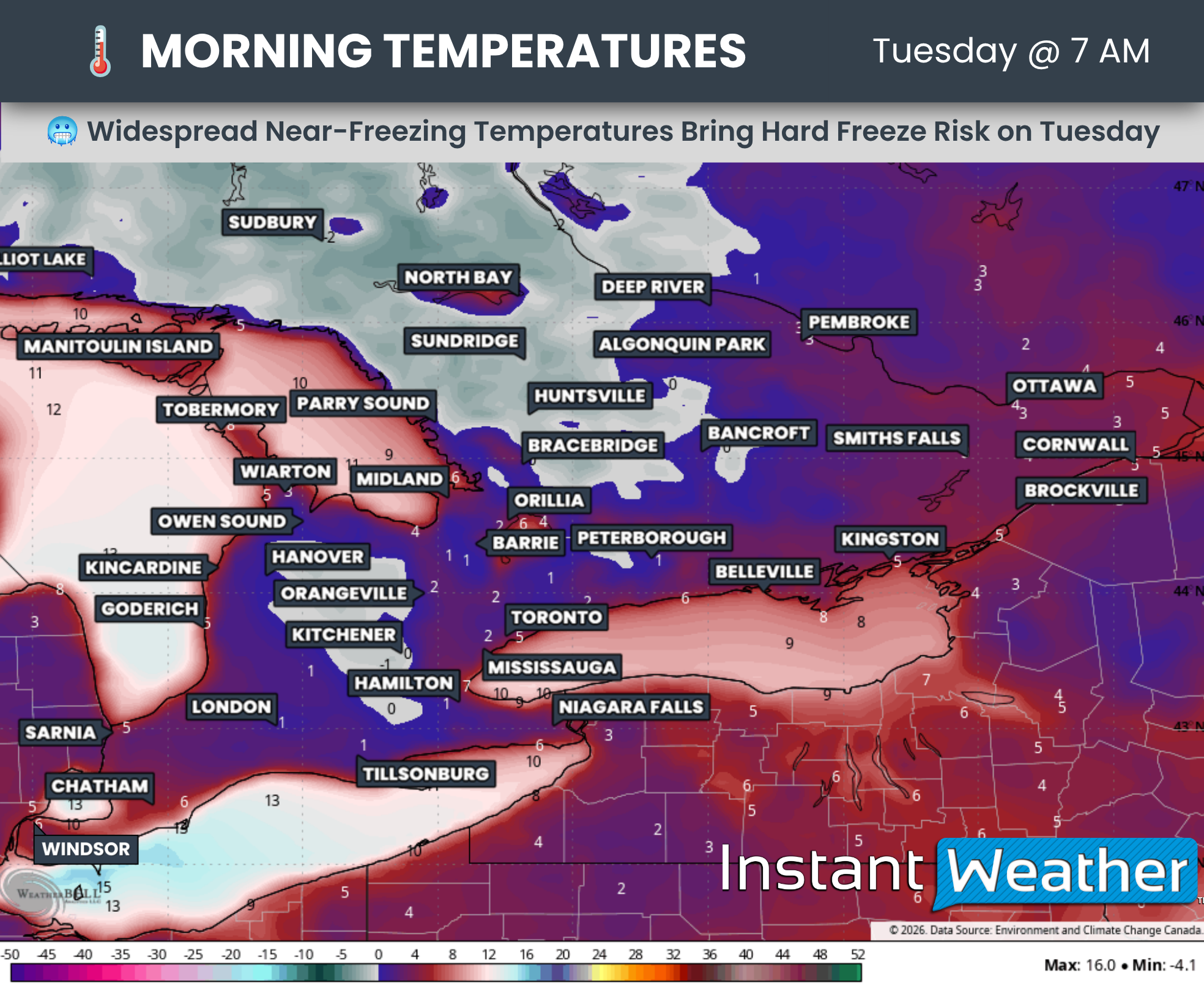
While those farther south are expected to escape the snowy surprise, a taste of winter-like weather is still on the way. Temperatures could fall below freezing early Tuesday, October 6, across Central Ontario and the higher elevations of Southwestern Ontario, particularly around the Dundalk Highlands.
A widespread freeze is possible in these areas, with a hard freeze possible in colder locations. Frost could also develop in portions of the Golden Horseshoe.
DATA FROM WEATHERBELL
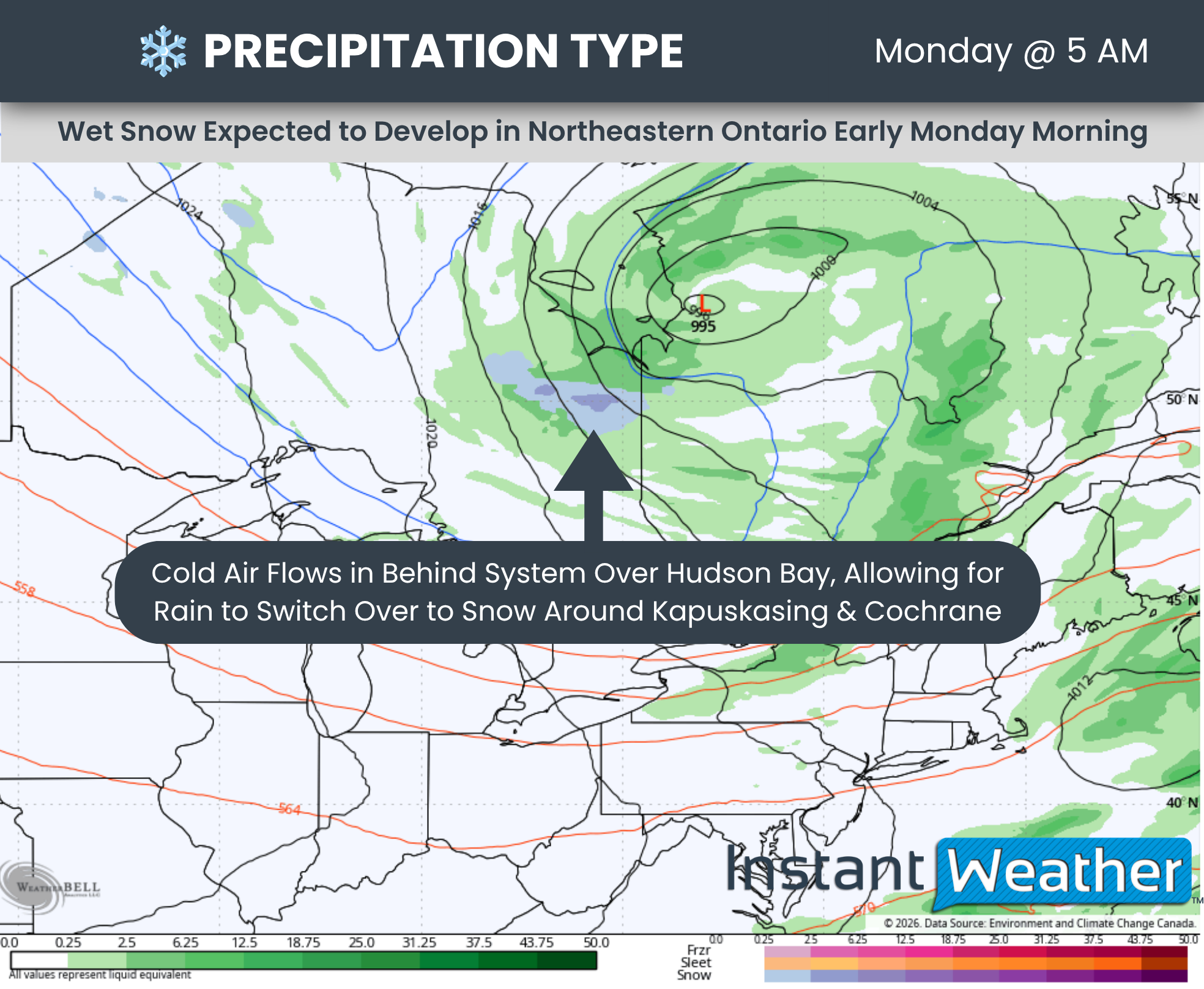
The low-pressure system tracking near Hudson Bay and James Bay is bringing steady rain to parts of Northern Ontario throughout Sunday. As it begins to pull away, a surge of colder air will move in behind it, allowing some of that rain to mix with or change to wet snow.
This transition could begin as early as midnight in areas north of Hearst and Kapuskasing before spreading south and east into the Kapuskasing and Cochrane areas during the pre-dawn hours.
There is still some disagreement among forecast models about how widespread the changeover will be. Some communities may see a period of wet snow, while others could see only a few flakes mixed with rain.
Areas along the James Bay shoreline, including Moosonee, may remain just warm enough for rain. The relatively warm waters of the bay could help keep temperatures slightly higher near the shoreline, even as areas farther inland see wet flakes.
By mid-morning Monday, the area of rain and wet snow is expected to extend across the Quebec border. This will bring the potential for wet flakes to portions of Western and Central Quebec through the late morning and early afternoon, although the extent of the changeover remains uncertain.
The snow potential should diminish by late afternoon as temperatures gradually rise, allowing any remaining mixed precipitation or wet snow to transition back to rain.
DATA FROM WEATHERBELL
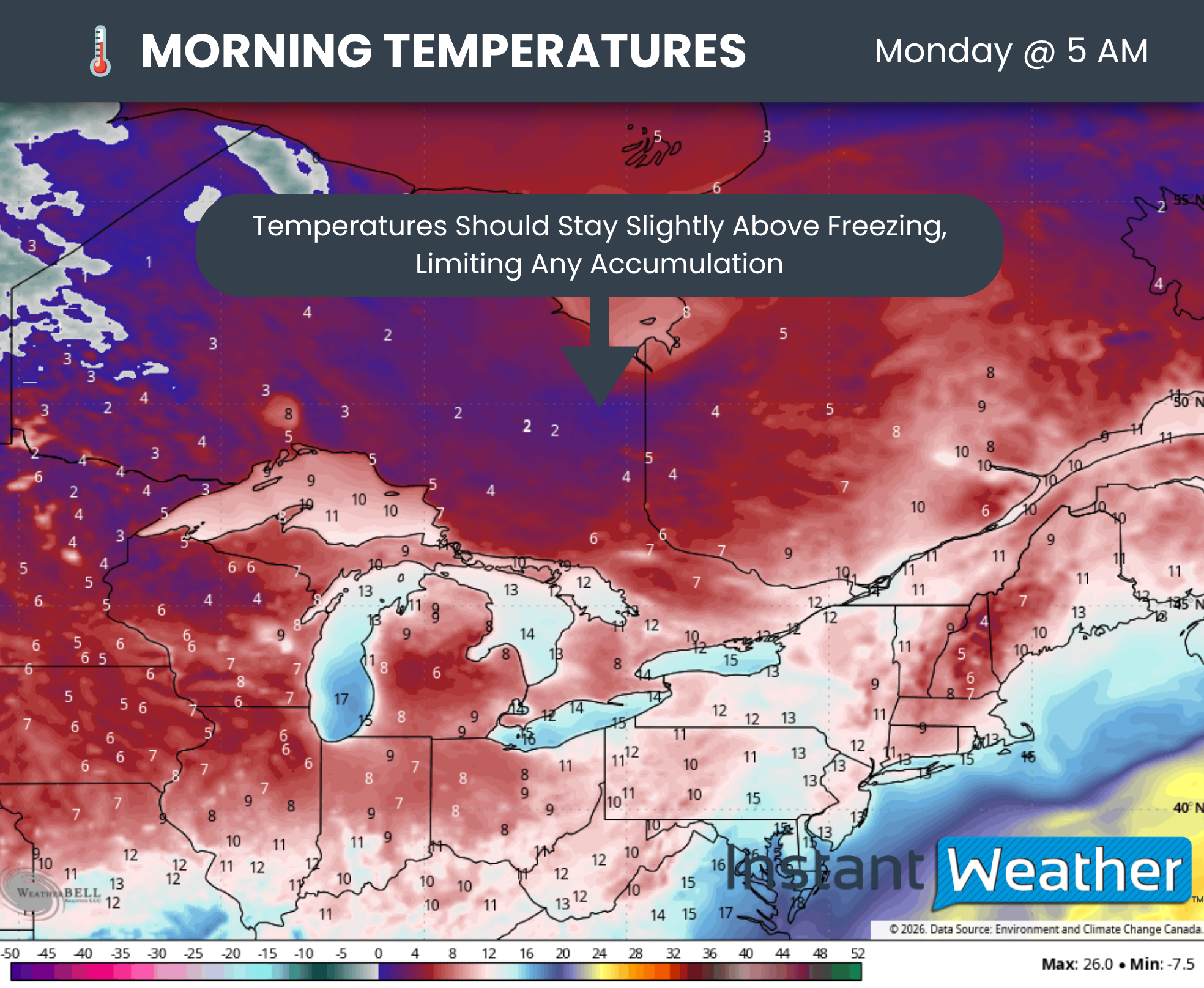
One important factor with this early-season snowfall is that temperatures are expected to remain slightly above freezing while the snow is falling. Forecast models suggest readings around 1°C to 2°C in areas that could see wet snow.
Snow can still reach the ground at these temperatures when the layer of above-freezing air near the surface is too shallow to melt the flakes completely. However, with the ground still relatively warm, much of it will likely melt on contact.
If temperatures end up a little colder than forecast, some light accumulation could greet you on Monday morning, particularly on grassy areas and elevated surfaces.
Snow can briefly accumulate even slightly above freezing if it falls heavily enough, but anything that sticks should melt as temperatures climb later in the day. For most locations, this looks more like a chance to spot a few flakes than a lasting coating of snow.
DATA FROM WEATHERBELL

Turning to Southern Ontario, we are not currently expecting the snow potential to reach that far south. However, it will still be a chilly start to the first full week of October.
Tuesday could bring the coldest morning of the season so far to parts of the region. Below-freezing temperatures are expected across much of Central Ontario, extending into the higher elevations of the Dundalk Highlands northwest of the GTA.
This raises the potential for a widespread freeze, with a hard freeze possible where temperatures fall a few degrees below freezing and remain there for several hours.
A hard freeze generally means temperatures fall to around -2°C or colder for several hours. This can freeze moisture within plant tissues, damaging or killing sensitive flowers, vegetables and other seasonal plants. For some gardens, it could effectively bring the growing season to an end.
The duration of the cold will matter as much as the overnight low. A brief dip below freezing may have less impact than several hours of colder temperatures, so not every location that drops below 0°C will experience a hard freeze.
If you still have sensitive plants outdoors, plan to bring potted plants inside and protect anything you hope to keep growing before temperatures drop Monday night.
Frost is also possible in portions of the Golden Horseshoe early Tuesday, so those farther south may want to take precautions with sensitive plants as well.