Severe Thunderstorms Possible for Manitoba Thursday, But Risk Remains Questionable
/
NOTE: YOU CAN CLICK ON THE MAP TO OPEN A ZOOMABLE IMAGE
The southern half of Manitoba, particularly in the southeast, could see some severe thunderstorms today when a cold front tracks through the region. However, in typical Manitoba fashion, whether storms end up even developing today is very questionable.
The cold front will begin to move through Southern Manitoba early this afternoon and it should reach the Winnipeg area around the late afternoon or early evening hours. Normally, a cold front is more than enough to trigger severe thunderstorms, but the issue is that there is expected to be a significant amount of capping in the atmosphere today, which would greatly inhibit thunderstorm development.
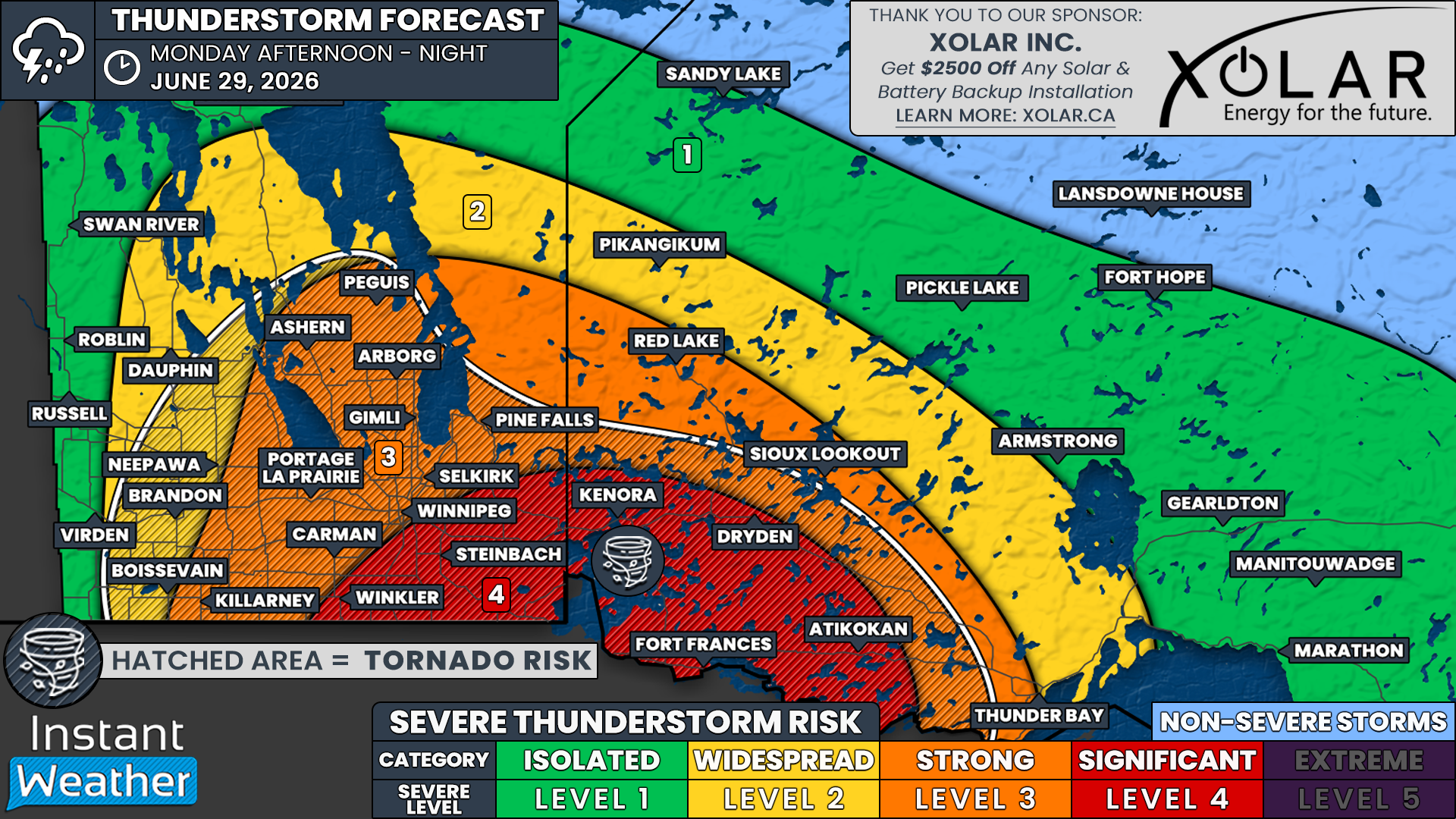
Due to this capping, there is considerable disagreement between weather models regarding when and where thunderstorms could end up forming today. There are those that show storms initiating in Southern Manitoba beginning in the late afternoon, while other models have storm development beginning much later, once the cold front has crossed into Northern Ontario. To cover this range in possibilities, our forecast has a Slight risk from the Red River Valley to the Ontario border.

The hrdps model showing thunderstorms to the south and east of lake Winnipeg at 6pm CT, courtesy of WeatherBell.
If storms end up developing in Manitoba later today, they will likely start off as isolated supercell thunderstorms along the front that should then quickly merge into a line of storms that continues tracking eastward. These could end up being quite strong storms, especially since the same cold front triggered strong severe thunderstorms in Central Saskatchewan yesterday which produced some very damaging winds, large hail, and even a few tornado warnings.
The risks in Manitoba today are much the same if the storms end up developing here: very strong wind gusts that could be well in excess of 100km/h, hail up to the size of tennis balls, and torrential downpours that could lead to localized flooding. There is also the possibility of an isolated tornado, especially closer to the Ontario border.
We will be keeping an eye on how the situation unfolds today and if storms end up forming within the province later today, we will provide updates and probably livestream.