Snowy Scare: Frightful Flurries May Haunt Parts of Southern Ontario on Halloween Night
/

NOTE: YOU CAN CLICK ON THE MAP TO OPEN A ZOOMABLE IMAGE
After a soggy start to Halloween Eve across Southern Ontario on Thursday, a strong system will cast a gloomy spell over the region with widespread rainfall. But don’t be fooled, as that’s only a taste of what Mother Nature has brewing in her cauldron for Halloween itself.
Last year, we were treated to a mild and friendly Halloween with temperatures that felt more like a trick than a treat. This year, however, it looks like Halloween will send a real shiver down your spine as temperatures drop to levels more fitting for the undead.
Rain from Thursday is expected to linger overnight and into the early hours of Friday, heavy at times, especially across Eastern Ontario. The good news is that the worst of the rainfall should clear out just in time for trick-or-treating across Southwestern Ontario and the Golden Horseshoe. Temperatures will hover around what’s normal for this time of year, ranging from the mid to upper single digits, possibly reaching the low double digits in Deep Southwestern Ontario.
But it’s as if a witch has placed a chilling curse over Central and Eastern Ontario. As the rain lingers through Friday, some areas could begin to see strange white shapes drifting through the sky and no, they aren’t ghosts! These spooky apparitions are far more real, as rain could turn to wet flurries as early as Friday afternoon. Cold air will creep in like a Halloween fog, sending temperatures tumbling toward the freezing mark by evening.
While there’s some disagreement between models (a classic case of meteorological mischief), there’s solid agreement that a wide stretch of Central Ontario may experience at least a few wet flurries on Halloween night.
Where the models differ is in timing and intensity. Some are quite aggressive, conjuring an earlier and more widespread switchover to snow that could even allow for light accumulations in higher elevations. Others show a less frightful outcome, with flurries limited to the hills and highlands later in the day as the rain fizzles out elsewhere.
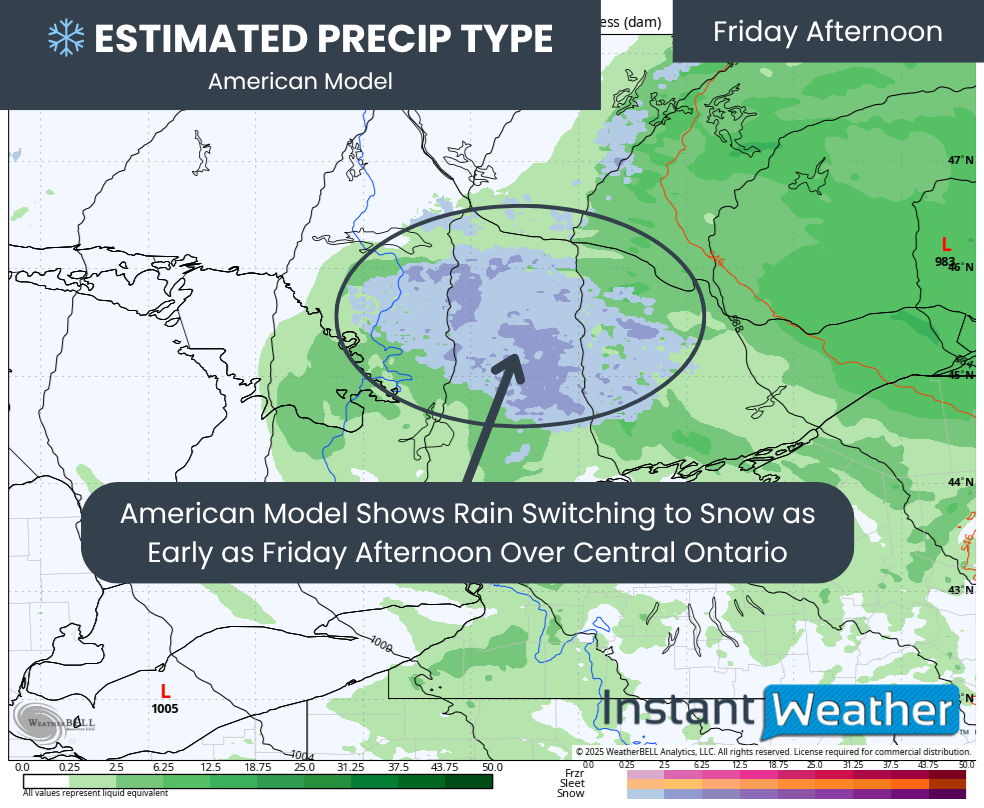
PRECIP TYPE - MAP FROM WEATHERBELL
As we rise on Halloween morning, rain will still be haunting much of Southern Ontario, though it will begin to taper off from west to east.
That’s where the great model split begins. For this forecast, we’re focusing on the NAM (American) and HRDPS (Canadian) models, which represent two distinct camps. The European model seems to be siding with the Canadian solution.
The American model pulls colder air into Central Ontario faster, dropping temperatures a few degrees lower than the Canadian model. It might not sound like much, but when temperatures hover near freezing, every degree counts. This could allow snow to start mixing in by early afternoon.
Areas like Algonquin Park, Haliburton, Bancroft, and northern Muskoka may see the first flurries, with the “mixing zone” spreading south through the afternoon into Muskoka, northern Simcoe County, and the Kawartha Lakes region.

PRECIP TYPE - MAP FROM WEATHERBELL
The Canadian model delays the switchover until closer to dinnertime, mainly over higher elevations.
By then, the precipitation in western areas may already be fading, keeping Muskoka and Simcoe County mostly rain-soaked rather than snow-covered.

PRECIP TYPE - MAP FROM WEATHERBELL
If the American model’s spookier version plays out, several hours of heavy, wet snow could fall Friday evening. While the ground is still warm, we’ve seen before that a strong enough burst of snow can briefly overcome that warmth and start to accumulate.
This model also spreads the snowy risk zone further east, even hinting at flakes creeping into the Ottawa Valley.

NOTE: YOU CAN CLICK ON THE MAP TO OPEN A ZOOMABLE IMAGE

The most likely areas to see actual snow include the higher elevations of Central Ontario, such as Sundridge, Huntsville, Algonquin Park, and Bancroft. These regions could even pick up a few slushy centimetres by night’s end if the stronger scenario comes true.
Elsewhere across Central Ontario, including Parry Sound, Bracebridge, Orillia, Kawartha Lakes, Tweed, and Pembroke, some wet flakes could mix in as trick-or-treaters prowl the streets. Accumulation isn’t expected here as the ground remains too warm, but it might add an extra eerie touch to the evening.

ESTIMATED PRECIP OVER LAST 3 HOURS - MAP FROM WEATHERBELL
As the ghosts, goblins, and ghouls hit the streets after nightfall, Southwestern Ontario will enjoy the calmest conditions, with rain clearing out hours earlier.
Central and Eastern Ontario, however, may not be as lucky. Light rain or even a few flurries could continue into the early evening, adding some spooky atmosphere to the night.
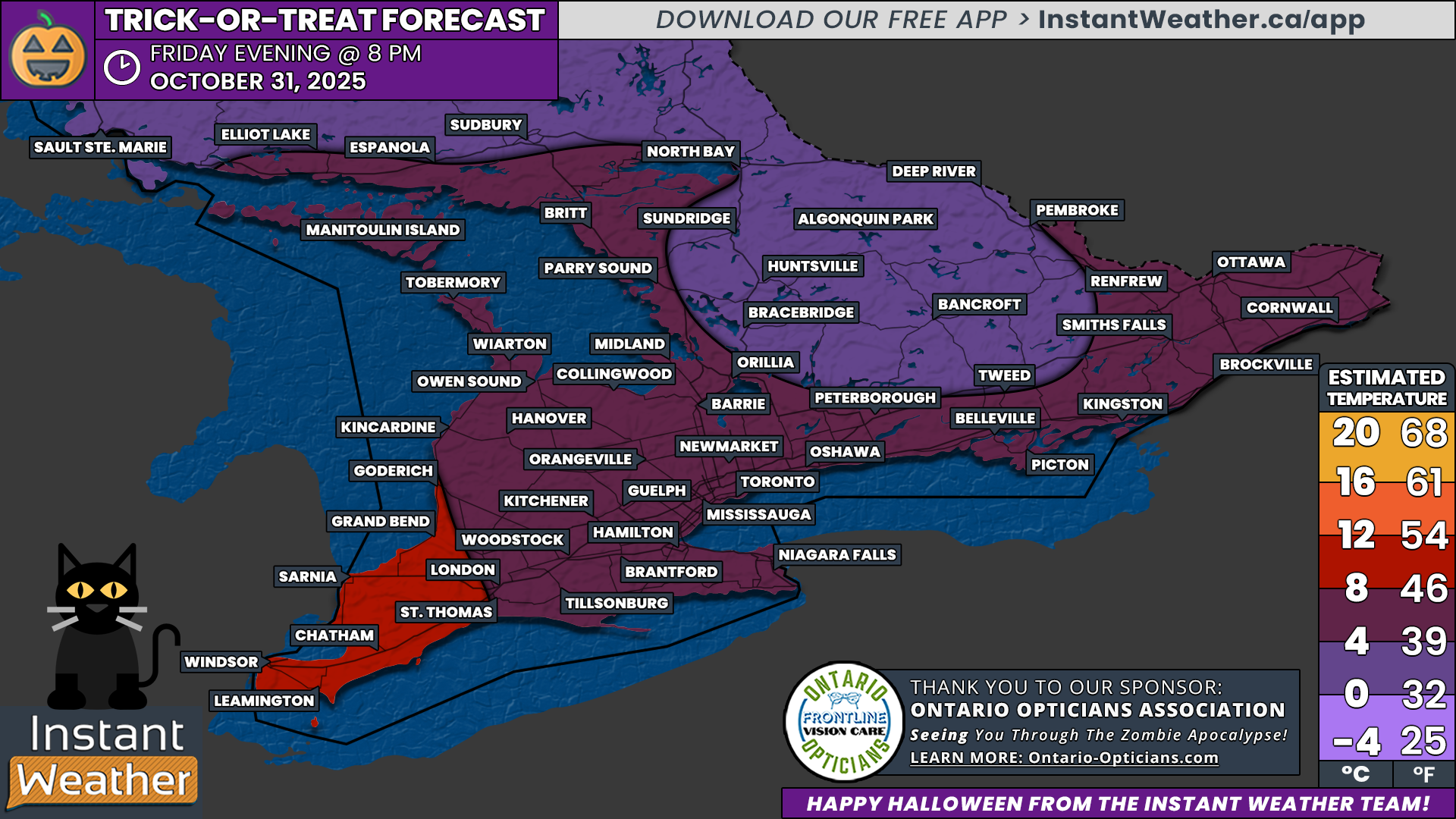
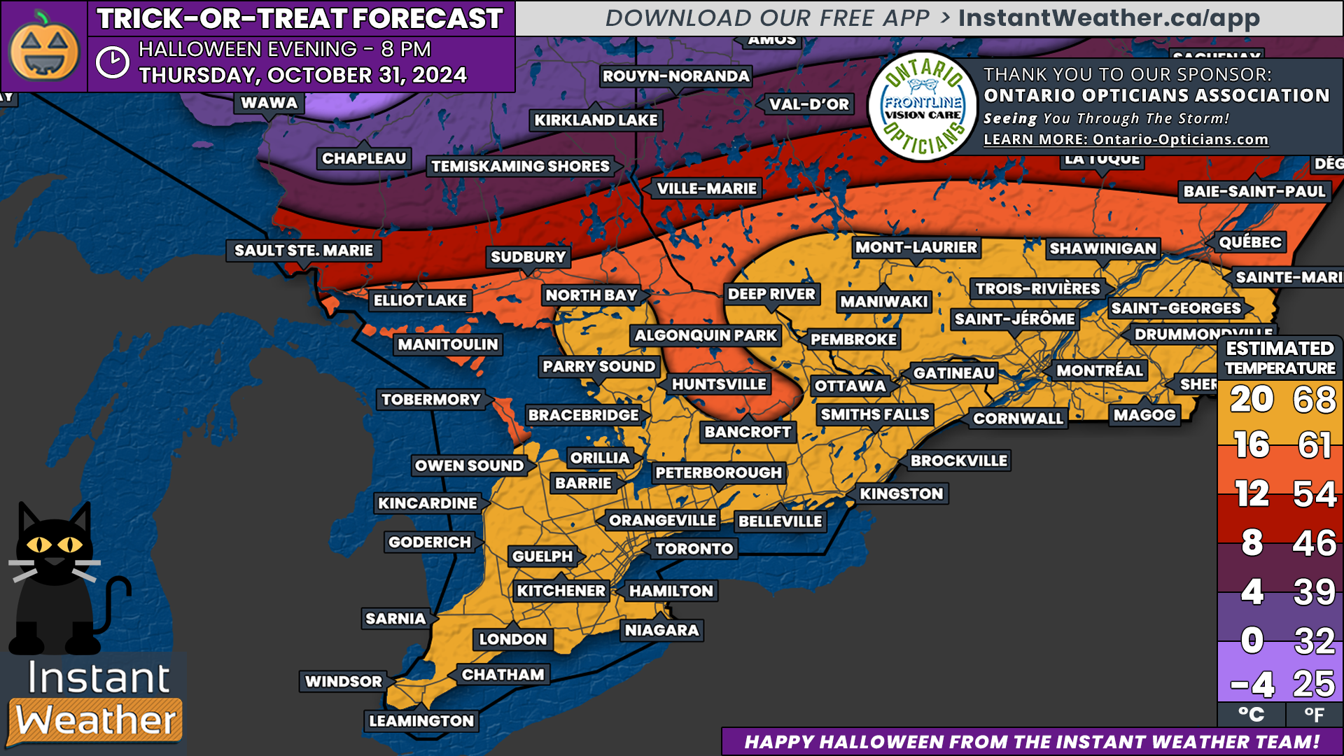
NOTE: YOU CAN CLICK ON THE MAP TO OPEN A ZOOMABLE IMAGE
For the prime trick-or-treating hours, Deep Southwestern Ontario will be the mildest, with temperatures around 8 to 12°C at 8 PM. Elsewhere across the Golden Horseshoe and Eastern Ontario, temperatures will settle into the mid to upper single digits.
The chilliest readings will haunt Central Ontario, where places like Muskoka, Algonquin Park, and Bancroft may see readings near the freezing mark with flakes swirling through the air. Those heading out should make sure their costumes have a few extra layers because this Halloween, it’s not just the monsters giving people chills.
Have a Happy Halloween!