Environment Canada Forecasting Major Storm in Ontario With Heavy Snow, Freezing Rain, Rain, and Damaging Winds From Sunday Through Tuesday
/Environment Canada is forecasting a major winter storm that is expected to sweep across Ontario from Sunday through Tuesday, bringing a wide range of impacts across the province. Depending on where you’re located, this storm may bring heavy snow, blowing snow, freezing rain, heavy rain, strong winds, and snow squalls.
The most significant concerns appear to be in northeastern Ontario, where very heavy snowfall is expected, as well as parts of southern Ontario where strong winds, freezing rain, and changing precipitation types may lead to hazardous travel and possible power outages. Snowbelt regions east and southeast of Lake Huron and Georgian Bay could see intense snow squalls and continued strong winds into Tuesday.
Sunday: Snow Spreads In, With Ice and Wind Developing Later
NOTE: CLICK OR TAP THE IMAGE TO OPEN IT SO YOU CAN ZOOM IN
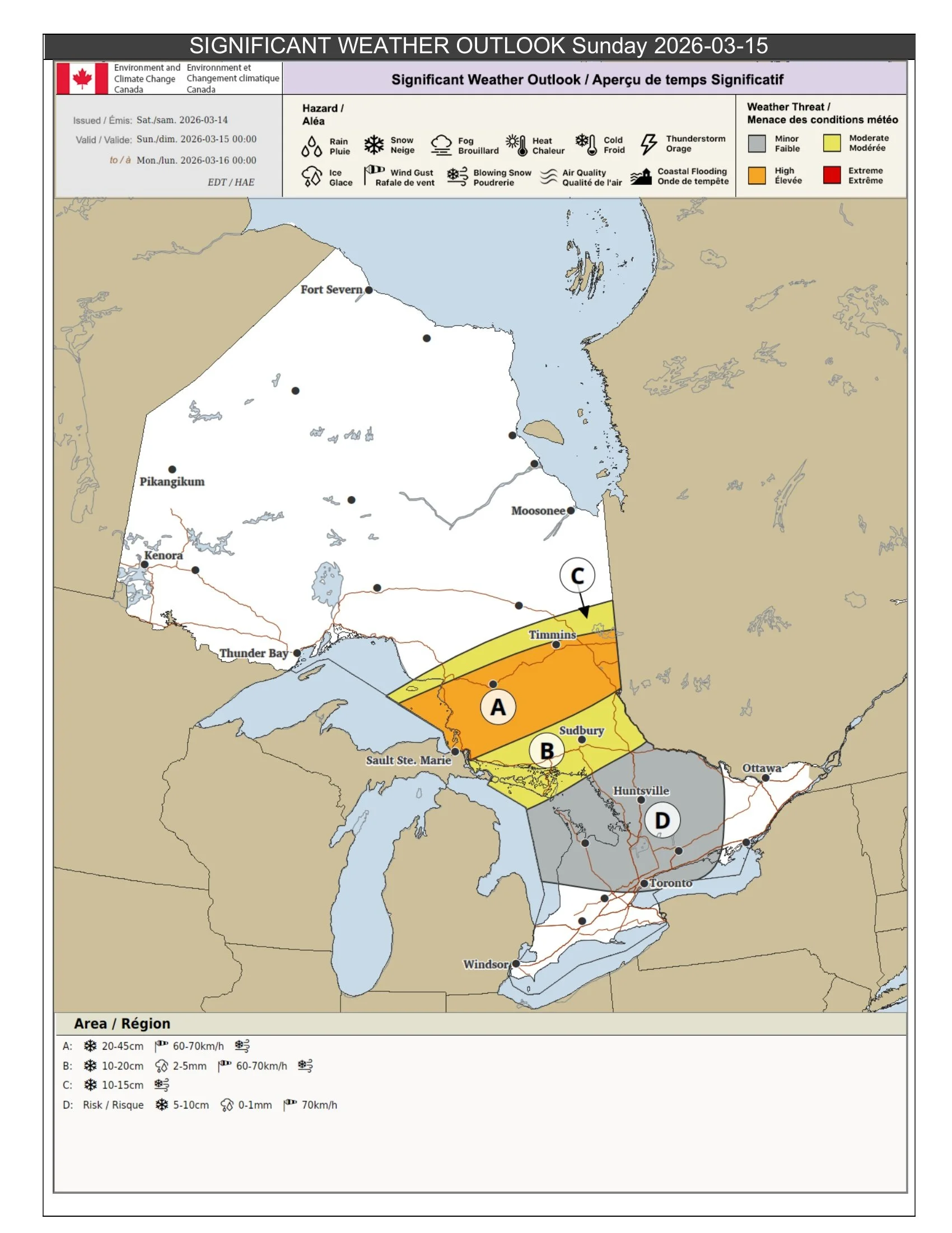
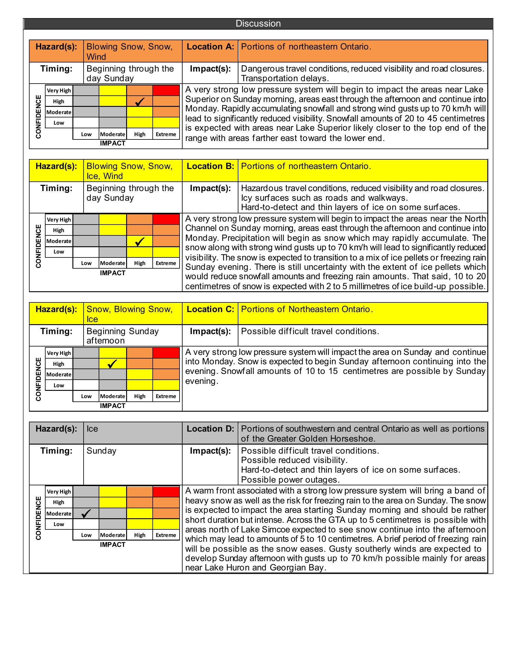
In northeastern Ontario, Sunday morning is looking rough and this will continue through the afternoon. Areas near Lake Superior could see 20-45 cm of snow with wind gusts up to 70 km/h according to Environment Canada, leading to significantly reduced visibility and dangerous travel. Some roads may become very difficult or even impossible to travel on as conditions deteriorate.
For the eastern side of northeastern Ontario, snow is expected to begin Sunday afternoon and intensify into the evening. Some areas may see 10-20 cm of snow before transitioning to a mix of ice pellets or freezing rain Sunday evening, while farther east, snowfall totals of 10-15 cm are possible by the end of the day.
Across southern Ontario, including parts of southwestern and central Ontario and the Greater Golden Horseshoe, Sunday is expected to bring a quick burst of heavy snow beginning in the morning. Up to 5 cm may fall in the GTA, while areas north of Lake Simcoe could see 5-10 cm where snow lingers longer into the afternoon.
As temperatures rise, some areas may briefly change to freezing rain before precipitation tapers off. At the same time, southerly winds may strengthen, with gusts up to 70 km/h developing Sunday afternoon, especially near Lake Huron and Georgian Bay. Travel conditions may quickly shift from snow-covered roads to slushy and icy surfaces.
NOTE: CLICK OR TAP THE IMAGE TO OPEN IT SO YOU CAN ZOOM IN
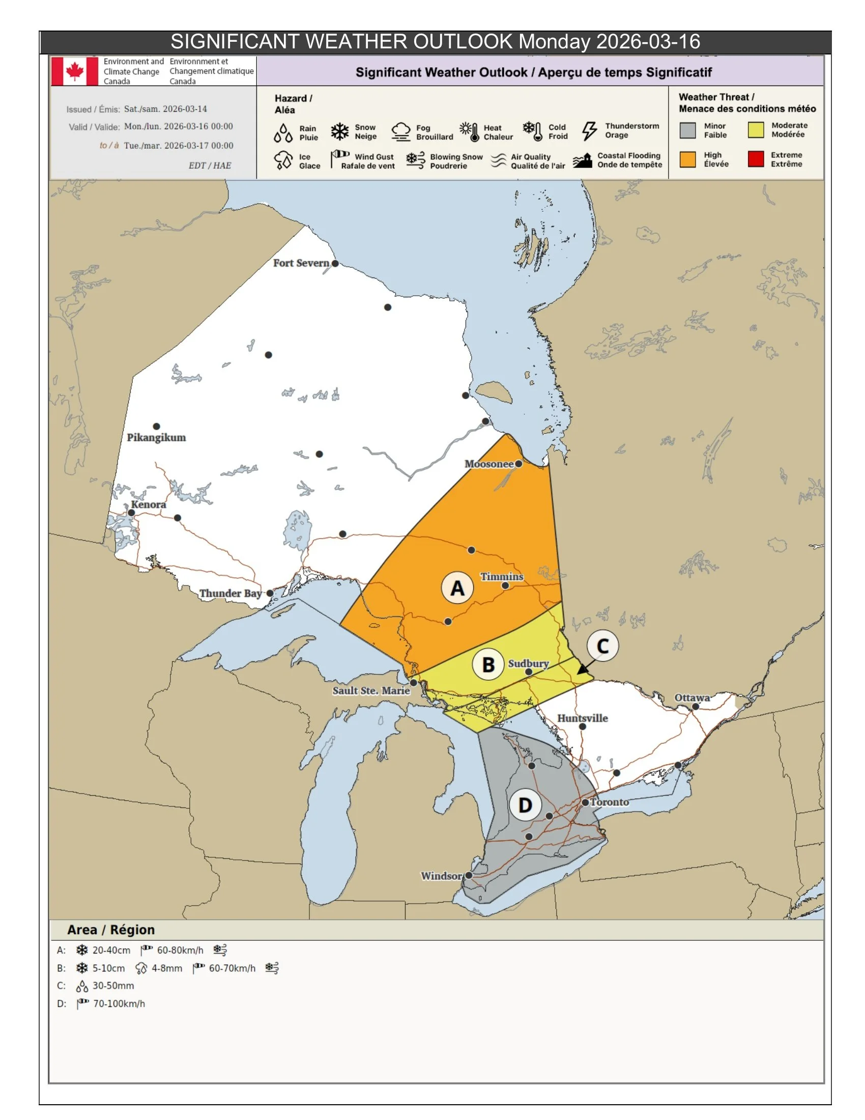
Monday: Peak of the Storm Brings the Most Widespread Impacts
NOTE: CLICK OR TAP THE IMAGE TO OPEN IT SO YOU CAN ZOOM IN
Monday is shaping up to be the most impactful day of the storm, with multiple hazards affecting different parts of Ontario.
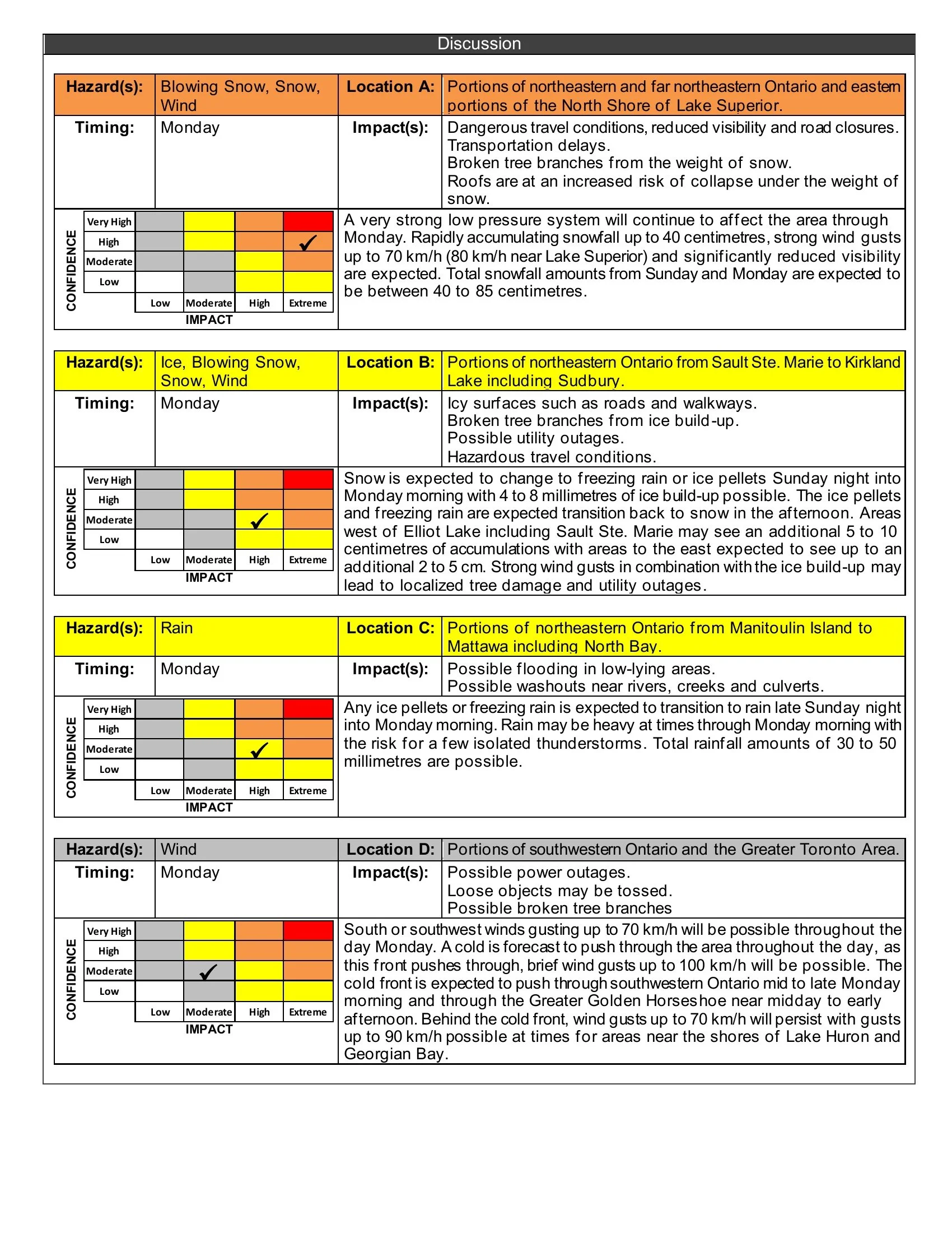
In northeastern and far northeastern Ontario, along with eastern sections of the North Shore of Lake Superior, the storm is expected to continue producing heavy snow, blowing snow, and very poor visibility. Additional snowfall of up to 40 cm is possible Monday alone, with wind gusts up to 70 km/h and up to 80 km/h near Lake Superior. Combined snowfall totals from Sunday through Monday could reach 40-85 cm in some areas.
This could lead to dangerous travel, possible road closures, broken tree branches, and an increased risk of roof collapse where the heaviest snow falls.
A separate corridor from Sault Ste. Marie to Kirkland Lake, including Sudbury, is expected to deal with a messy mix of snow, freezing rain, ice pellets, and wind. Snow is expected to change to freezing rain or ice pellets Sunday night into Monday morning, with 4-8 mm of ice build-up possible. During Monday afternoon, precipitation is expected to change back to snow. Additional snowfall of 5-10 cm is possible west of Elliot Lake, with 2-5 cm farther east.
This combination of ice and wind may lead to localized tree damage and power outages.
From Manitoulin Island to Mattawa, including North Bay, the storm is expected to transition from freezing rain or ice pellets to heavy rain late Sunday night into Monday morning. Rainfall totals of 30-50 mm are possible, along with the risk of a few isolated thunderstorms.
This may lead to localized flooding, especially in low-lying areas and near rivers, creeks, and culverts.
In southwestern Ontario and the Greater Toronto Area, Monday increasingly looks like a high-impact wind event. South or southwest winds gusting up to 70 km/h are expected through the day, but as a cold front moves through, brief gusts up to 100 km/h may be possible.
The front is expected to move through southwestern Ontario by mid to late Monday morning, then through the Greater Golden Horseshoe around midday to early afternoon. Behind the front, winds are expected to remain strong, with gusts up to 70 km/h continuing and up to 90 km/h possible near Lake Huron and Georgian Bay.
Loose outdoor items may be tossed around, tree branches could break, and scattered power outages are possible.
NOTE: CLICK OR TAP THE IMAGE TO OPEN IT SO YOU CAN ZOOM IN
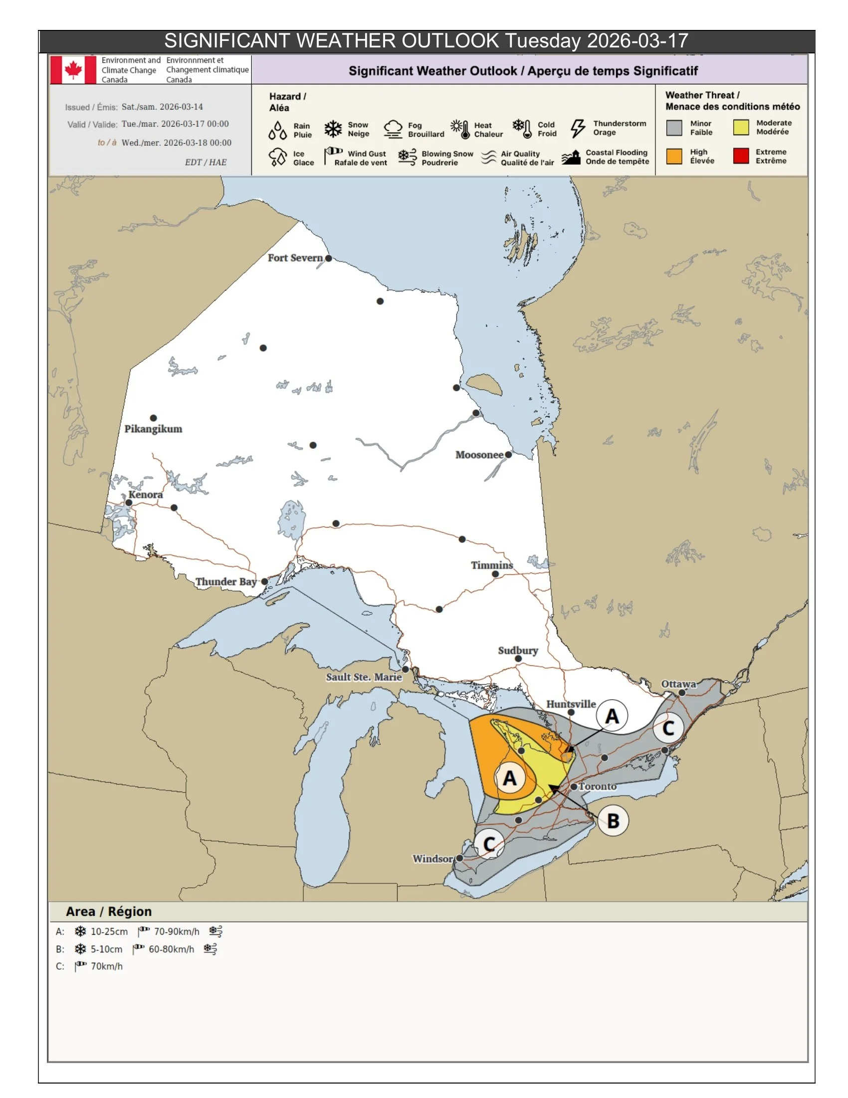
Tuesday: Snow Squalls and Strong Winds Continue
NOTE: CLICK OR TAP THE IMAGE TO OPEN IT SO YOU CAN ZOOM IN
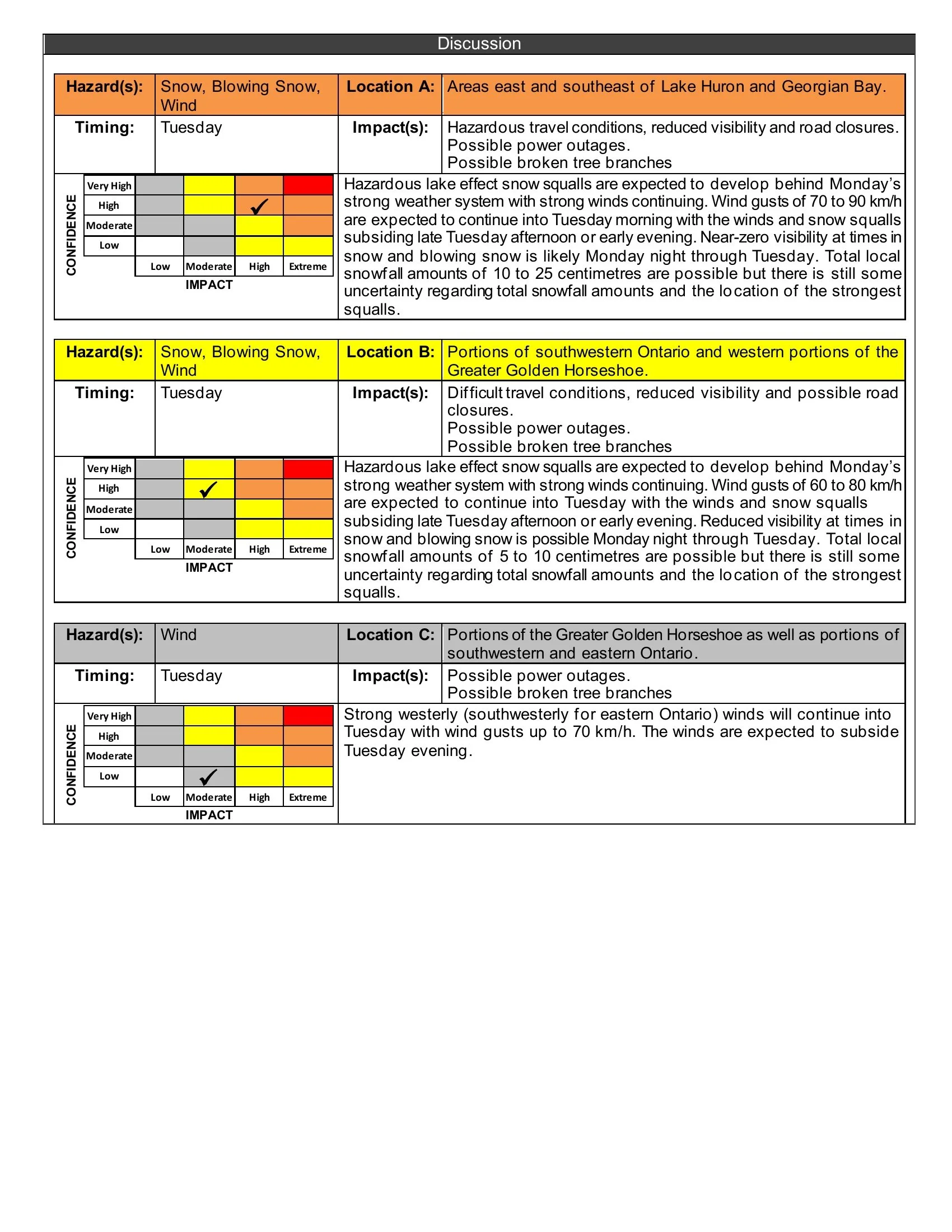
By Tuesday, the main storm system will begin to pull away, but conditions will remain hazardous in some areas as strong winds and lake effect snow squalls develop behind it.
The greatest concern will be east and southeast of Lake Huron and Georgian Bay, where snow squalls are expected to set up Monday night and continue into Tuesday. Wind gusts of 70-90 km/h may persist into Tuesday morning, and near-zero visibility is likely at times in snow and blowing snow. Local snowfall totals of 10-25 cm are possible before conditions gradually improve late Tuesday afternoon or early evening.
Portions of southwestern Ontario and the western Greater Golden Horseshoe may also see snow squalls on Tuesday, although totals there are expected to be somewhat lower, generally around 5-10 cm. Winds may still gust to 60-80 km/h, creating difficult travel and sharply reduced visibility at times.
Even outside of the strongest snow squalls, strong winds will remain an issue across parts of southern and eastern Ontario, with gusts up to 70 km/h possible before easing Tuesday evening.
Bottom Line
This is shaping up to be a high-impact storm for Ontario, with several different hazards depending on your location.
Northeastern Ontario faces the greatest risk for very heavy snow and blowing snow. Parts of central and northern Ontario may have to contend with freezing rain and heavy rain. Southern Ontario is at risk for strong to damaging winds, and snowbelt regions could see hazardous snow squalls into Tuesday.
Anyone with non-essential travel plans should reschedule if the conditions are bad for your area and if you have critical travel plans, you need to be prepared for rapidly changing conditions and the potential for significant disruptions. Power outages, dangerous highway conditions, and localized flooding will all be on the table as this storm moves through, depending on where you’re located. Download our free app InstantWeather to know when and where the conditions are going to get dangerous. Be safe, folks!