First Tornado of 2024 Confirmed in Ontario on March 16th; Ties With Earliest Tornado on Record

NOTE: YOU CAN CLICK ON THE MAP TO OPEN A ZOOMABLE IMAGE

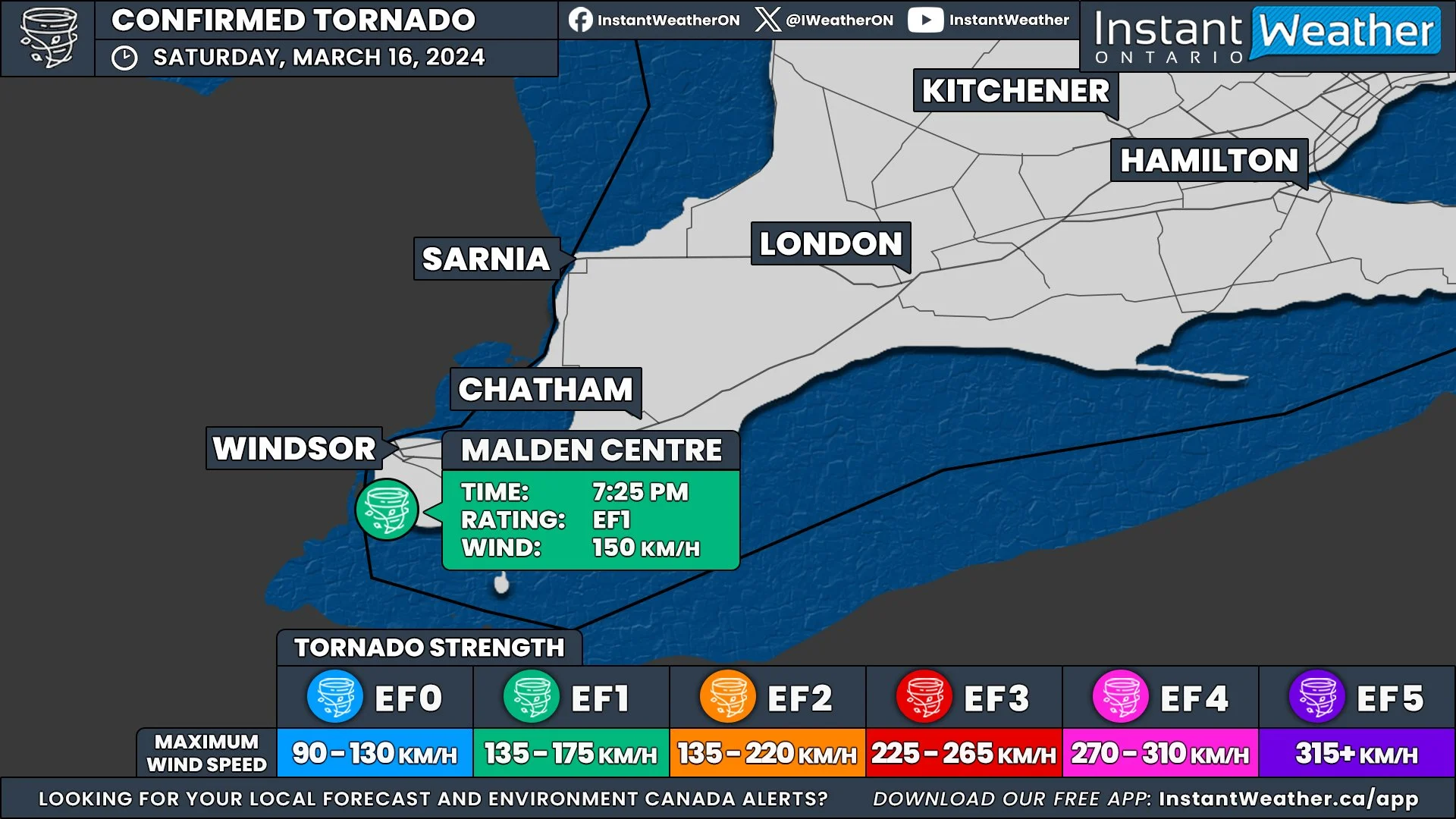
In an unusually early start to the tornado season, Ontario recorded its first confirmed tornado of the year on March 16th. This event ties with the record for the earliest tornado occurrence in the province, a record previously set in 2016 in Clifford, Ontario.


GOOGLE AD (NOT ENDORSED BY INSTANT WEATHER)

Map showing the tornado track just south of Malden Centre, and points where damage was documented.

SOURCE: NORTHERN TORNADOES PROJECT

The Northern Tornadoes Project (NTP) confirmed the tornado following a comprehensive damage survey in the Malden Centre area, south of Windsor, where significant damage was reported.


Roof debris downwind, and roof of second double-wide mobile home with half of its roof off.

SOURCE: Kevin Sprague / NORTHERN TORNADOES PROJECT

Rated as an EF1 on the Enhanced Fujita Scale, the tornado reached maximum wind speeds of about 150 km/h. The most significant damage was noted where a double-wide mobile home had its roof completely removed. Other damages included shingle destruction, a downed tree at another residence, and extensive damage to trees in surrounding woodlands.


GOOGLE AD (NOT ENDORSED BY INSTANT WEATHER)

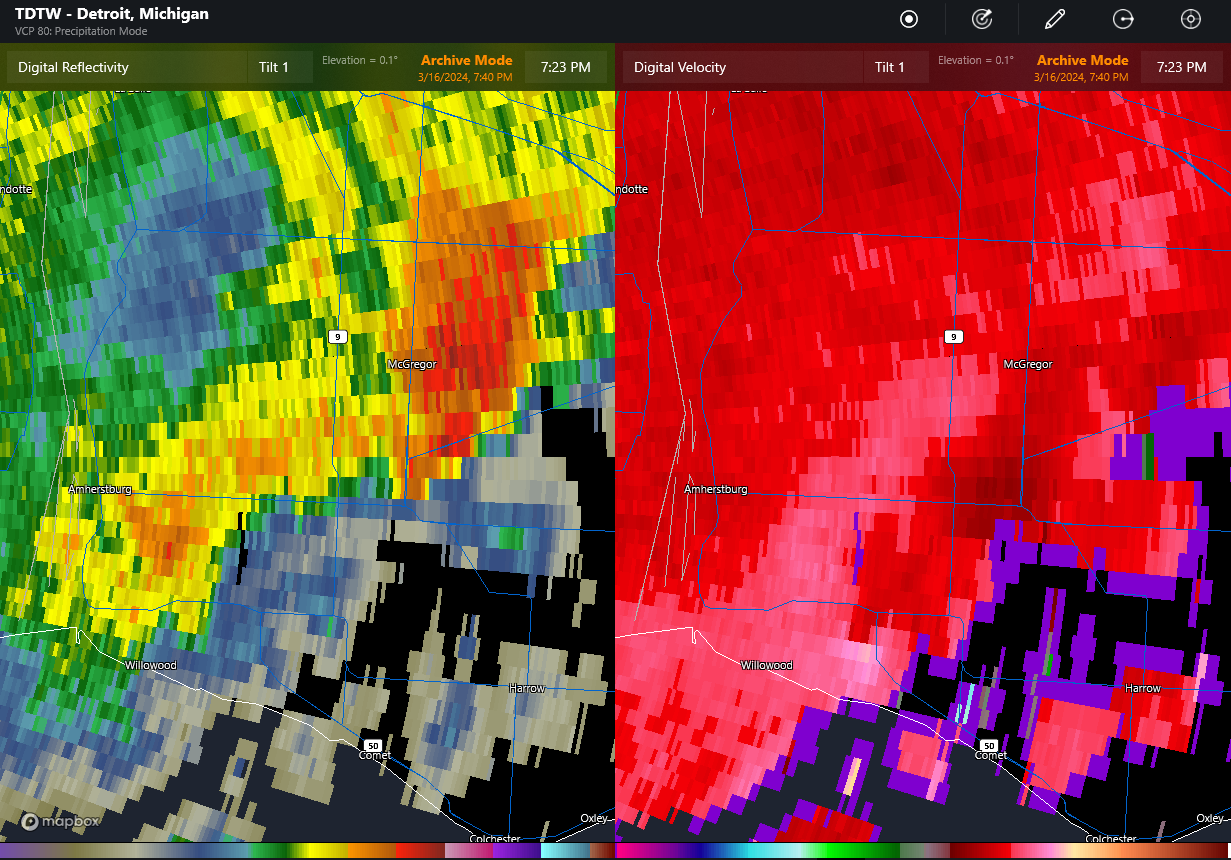
TDTW radar at 7:23 pm EDT showing main storm near Essex producing severe hail (left image), and gust front trailing back to the southwest with embedded area of rotation right over the location with the roof removed (lower middle of image at right). The rotation is apparent only in the two lowest tilts (second tilt not shown).

SOURCE: NORTHERN TORNADOES PROJECT

Classified as a QLCS (Quasi-Linear Convective System) tornado, it developed along the leading edge of a thunderstorm's outflow. Radar data from Detroit Metro Airport clearly showed a tight rotation at the exact locations of the reported damages. There were no preceding tornado warnings and no reports of severe weather from nearby Michigan, although the storm did produce severe hail in parts of Ontario.

Drone image showing trees down to the ESE along the path of the tornado (circled).

SOURCE: NORTHERN TORNADOES PROJECT

The tornado's path was approximately 1.10 kilometres long and reached a maximum width of 100 meters. The damage to trees was presumably less severe than it might have been if the trees had been in leaf, which could have resulted in more extensive damage.


GOOGLE AD (NOT ENDORSED BY INSTANT WEATHER)

Three Additional Tornadoes Confirmed Across Alberta From Earlier in 2023

After each tornado season, the Northern Tornadoes Project (NTP) reviews satellite imagery of treed areas across the country to find evidence of tornado damage that may have been missed due to a lack of reports or poor radar coverage.

After completing their review of Alberta, the NTP has catalogued three new tornadoes for the 2023 season. With the additional confirmed tornadoes, the overall 2023 tornado count for Alberta stands at 19.


GOOGLE AD (NOT ENDORSED BY INSTANT WEATHER)

The first new tornado was an EF1 that touched down near Lawrence Lake, to the east of Hondo, at approximately 4:00 pm on May 23rd, with an estimated maximum wind speed of 145km/h.

The second tornado was also an EF1 and this one touched down near McGregor Lake, northeast of Nordegg, on June 17th at approximately 1:10 pm with estimated maximum wind speeds of 145km/h.

The third tornado was an EF0 west of Cynthia. This particular tornado was found as a result of a private drone survey that showed tornadic tree damage in a forest that had recently been impacted by a fire. Further investigation established that this tornado had touched down at approximately 6:05 pm and had maximum wind speeds of 105km/h.


GOOGLE AD (NOT ENDORSED BY INSTANT WEATHER)

Rare Tornado in Vancouver on Saturday, November 6, 2021

A very rare occurrence happened this past Saturday when an EF0 tornado caused some minor damage in the Vancouver area. Tornadoes are rare enough in British Columbia but especially in November!

Environment Canada tweeted about a meso-low at 5:07 pm.

Video and photos were captured of a tornado over the Strait of Georgia that came ashore and caused damage to the University of British Columbia.

This video was taken at the UBC Golf Club as the tornado came through. Note the tree falling (0:07) and the blue flash (0:10) as power lines go down.

ECCC issued a Tornado Watch at 5:30pm.

In the video below of the aftermath of the Tornado at UBC you can see tree limbs and tree damage as well as damage to at least one car at the very end of the video.

Power outages were also noted in this tweet and prompted the discussion of the possibility that the tornado may have crossed the Burrard Inlet.

ECCC Weather British Columbia issued this tweet.

It is confirmed that an EF0 tornado occured at 5:10 pm PDT at UBC near University Golf Club (estimated wind speed 90-110 km/h). Damage includes broken trees/tree limbs, scattered tree debris, uprooted trees, downed power lines, and tree damage to vehicle.

Tornadoes are rare in British Columbia but they do occur. Prior to yesterday there were three tornados reported recently in BC:

  • EF0 in Mission on September 16, 2018

  • EF0 in Saanich on May 21, 2020

  • EF0 in Fort St. John on August 21, 2020

There have also been reports of non-supercell tornadoes over water in the Strait of Georgia. Three concurrent ones on June 9, 2021 and two concurrent ones on June 10, 2021.

Tornadoes in Vancouver or the surrounding area are very rare. The last confirmed tornado in Vancouver was in 1976 and in the area of Vancouver in 1991 (Pitt Meadows):

So grateful that no one was hurt and here's hoping this remains a rare occurrence.

42ND TORNADO OF THE YEAR CONFIRMED From Nov 15 Windstorm Adds to the Already Record Breaking Tornado Season!

NTP event map (blue EF0, green EF1)

NTP event map (blue EF0, green EF1)

The Northern Tornadoes Project (NTP) has confirmed an EF1 Tornado from the wind storm on November 15, 2020 in Georgetown, Ontario. In an already record breaking year, this is also one of the latest tornadoes that Ontario has experienced. The previous record for the most confirmed tornadoes in a year was set in 2009 with 37 tornadoes.

The Investigation map, drone and ground photos from NTP can be found here.

NTP also investigated and confirmed 4 downbursts at New Dundee (EF0), Port Burwell (EF0), Dunnville (EF0) and Ingersoll (EF1).

See the table below for details on the tornado and downbursts (from the NTP dashboard). Note how large the track lengths and path widths are for the downbursts. Tip: view the table in landscape mode on phones.

<

At 2:24pm, 21 minutes before the tornado touched down in Georgetown, we posted "Embedded, brief tornadoes are not entirely out of the question today with the strongest storms." This was included in a post about a potential tornado report in Port Burwell, which was later confirmed to be an EF0 downburst:

We also issued forecasts for this significant wind storm and here was the final forecast:

During the wind storm we also provided many updates to keep everyone informed:

Many people experienced power outages from the storm and Hydro One crews had to restore power to 370,000 customers in the most significant storm for Hydro One since May 2018.

Environment Canada issued a weather summary below for the event. They measured both thunderstorm wind gusts and non-thunderstorm wind gusts.

Weather summary
for Ontario and the National Capital Region
issued by Environment Canada
at 6:33 a.m. EST Monday 16 November 2020.

Discussion.

A powerful Fall Storm tracked through Ontario Sunday and Sunday 
night, bringing widespread destructive winds and severe 
thunderstorms to southern Ontario and strong winds and wintry 
weather to northern Ontario. 

The following is a summary of weather event information received by 
the Ontario Storm Prediction Centre. 

1. Summary of official thunderstorm wind gusts in kilometres per 
hour: 

Niagara District Airport: 141 
Port Colborne: 131 
Brampton-Caledon Airport: 120 
Windsor Airport: 111 
Baden Hill: 105 
Region of Waterloo Airport: 104 
Erieau: 102 
Hamilton Munro Airport: 102 
Point Petre: 102 
Toronto Pearson Airport: 100 
Chatham-Kent Airport: 100 
Toronto Billy Bishop Airport: 98 
Elora: 98 
Vineland: 98 
Muskoka Airport: 96 
Mono Centre: 94 
Western Islands: 91 
Ridgetown: 91 
Sarnia Chris Hadfield Airport: 89 
Egbert: 89 
London Airport: 85 
Harrow: 83 
Mount Forest: 81 
Peterborough Trent U: 81 
Cobourg: 81 
King City: 80 

Widespread damage from these thunderstorms has been reported across 
southwestern and south-central Ontario, including snapped utility 
poles, downed trees, and roof damage. 

2. Summary of official non-thunderstorm wind gusts in kilometres per 
hour: 

Port Colborne: 131 
Baden Hill: 122 
Toronto Billy Bishop Airport: 119 
Region of Waterloo Airport: 117 
Western Islands: 115 
Point Petre: 107 
Chatham-Kent Airport: 98 
Cobourg: 96 
Wiarton Airport: 93 
Windsor Airport: 91 
Erieau: 91 
Lagoon City: 91 
Toronto Pearson Airport: 91 
Mono Centre: 91 
CFB Trenton: 89 
Kingston: 89 
Goderich: 87 
London Airport: 87 
Killarney: 87 
Brantford Airport: 85 
Gore Bay-Manitoulin Airport: 85 
Oshawa AIrport: 85 
Welland: 83 
Vineland: 83 
Tobermory: 83 
CFB Borden: 83 
Harrow: 83 
Ridgetown: 83 
Muskoka Airport: 81 
Great Duck Island: 81 
Elora: 80 
Niagara District Airport: 80 
Sault Ste. Marie Airport: 80 

Widespread damage from this synoptic wind has been reported across 
southwestern and south-central Ontario, including snapped utility 
poles and downed trees. Between the thunderstorms and synoptic 
winds, well over 200 000 customers lost power on Sunday across the 
province. 

3. Summary of rainfall in millimetres: 

Shaw Dam Lake*: 57.7 
Massey*: 40.4 
Quirke Lake*: 40.3 

*denotes data from Ontario Ministry of Natural Resources and 
Forestry

Please note that this summary may contain preliminary or unofficial 
information and does not constitute a complete or final report.

End/OSPC

The high wind gusts in Port Colborne are likely responsible for this wayward shed.

Thank you to all those who have reported what they experienced during storms as your reports make all the difference when it comes to confirming tornadoes, downbursts, and any severe weather in our region.

Alberta: 2020 Summary of Tornadoes and Other Investigated Events

NTP summary of events

NTP summary of events

Below is a summary of the events in Alberta that were investigated by the Northern Tornadoes Project as of December 16, 2020. There are 11 confirmed tornadoes, 6 downbursts, and 1 unclassified wind damage event. There were also 27 non-tornadic events that were investigated. Links to the summaries for the other provinces can be found here.

Below is a map from the NTP Dashboard showing the location of the tornadoes.

Tornadoes

Tornadoes

Below is a map from the NTP Dashboard showing the location of the downbursts and unclassified wind event.

Downbursts

Downbursts

The details of the events are listed below and the comments are taken directly from the NTP Interactive Dashboard. Tip for viewing the table on a phone - try turning your phone so that you are in landscape mode.

Our thoughts are with all those affected by severe storms this year.

2020 Provincial Summaries

More provinces will be added once their summaries are completed.

British Columbia: 2020 Summary of Tornadoes and Other Investigated Events

NTP summary

NTP summary

Below is a summary of the events in British Columbia that were investigated by the Northern Tornadoes Project as of November 2 2020. There are 2 confirmed tornadoes and 1 downburst. They also investigated 5 other events that they classified as non-tornadic vortices. Links to the summaries for the other provinces can be found here.

The details of the events are listed below and the comments are taken directly from the NTP Interactive Dashboard. Tip for viewing the table on a phone - try turning your phone so that you are in landscape mode.

Tornadoes are rare in British Columbia. There were no confirmed tornadoes in 2019. One EF0 tornado occurred on September 16 2018 in Mission.

Our thoughts are with all those affected by severe storms this year.

2020 Provincial Summaries

More provinces will be added once their summaries are completed.

BREAKING: Friday’s Storm Produced at Least One Confirmed EF0 Tornado With 130km/h Estimated Wind Gusts

Map20201023-Confirmed.jpg

The Northern Tornadoes Project (NTP) and Environment & Climate Change Canada (ECCC) have confirmed an EF0 Tornado from Friday's storm in Thornbury, Ontario with estimated wind speeds of 130km/h.

INCREDIBLE Video of What Appears to Be a Tornado From Thornbury, Ontario During Friday's Storm: Video of what appears to be a tornado, filmed by Kim H.G. fro...

Our thoughts remain with those affected by Friday's storms and thankfully we haven't heard of any injuries, especially considering this incredible story from Mike Holder on Facebook (click the link to learn more):

Significant damage and incredible story from the Thornbury Harbour during Friday’s likely tornado (still under investigation). So glad you stayed safe, Mike! 😬 - Adam

Posted by Instant Weather Ontario on Sunday, October 25, 2020

Here's what Environment Canada wrote:

"Weather summary for Ontario and the National Capital Region issued by Environment Canada at 10:10 a.m. EDT Monday 26 October 2020.

Discussion.

A tornado has been confirmed by the Northern Tornadoes Project in Thornbury on October 23rd. The following is a summary of weather event information received by Environment Canada as of 9:00 A.M. EDT on Monday, October 26th, 2020.

Event Location:

Thornbury.

Event Description:

A tornado struck the area on the afternoon of Friday, October 23rd, 2020. The tornado followed a path through the town before entering Georgian Bay. The tornado has been given a preliminary rating of EF0 on the Enhanced Fujita scale with estimated maximum wind speeds up to 130 km/h and a path length of 3 kilometers. The tornado produced tree damage and damage to a power pole and street lamp.

This tornado accompanied several severe thunderstorms which affected areas near and east Georgian Bay on Friday afternoon with numerous reports of large hail up to the size of golf balls and strong winds. Meteorologists at the Ontario Storm Prediction Centre would like to thank the Northern Tornadoes Project for their continued work on analyzing and documenting tornadoes.

Please note that this summary may contain preliminary or unofficial
information and does not constitute a complete or final report.

End/OSPC"

We certainly agree with ECCC regarding the great work the NTP is doing and a huge shoutout to Dr. Sills, Dr. Kopp, and all those involved with the project!

Also, a huge thank you to Kim H.G. for the incredible video that clearly demonstrates the rotating wall cloud above the spray ring and the trailing rear-inflow jet or “ghost train”. Not to mention the howl in the video is very creepy and that classic "train in the distance" tornado sound that so many report.

Here's what the NTP tweeted:

And last but not least, here is the forecast map and forecast for Friday that was issued roughly twenty-four hours before the tornado touched down.

Thunderstorm_SON_Friday.jpg

Thank you to all those who have reported what they experienced during these storms as your reports make all the difference when it comes to confirming tornadoes, downbursts, and any severe weather in our region.

BREAKING: 39 Confirmed Tornadoes Breaks the All Time Ontario Record of 37 in One Season

Using hi-resolution satellite images, the Northern Tornadoes Project (NTP) has confirmed 5 more tornadoes in Ontario. This brings the total for 2020 up to 39 as of October 19th and breaks the record of 37 set in 2009.

As well, there are now 10 tornadoes that have been confirmed to have occurred during the tornado outbreak on June 10th.

NTP map of the June 10 Tornado Outbreak

NTP map of the June 10 Tornado Outbreak

The path of the EF2 tornado on July 13 at Stout Lake is clearly visible in the tweet by NTP below. This illustrates how satellite images can be used to investigate tornadoes.

NTP has completed their investigations of 101 events in Ontario with an additional 7 events currently under investigation. NTP determined that 39 of these events were tornadoes, 39 were classified as downbursts, 12 were non-tornadic vortices, 5 were waterspouts, and 6 were unclassified wind damage events (i.e. there was not enough evidence to determine the cause of the damage). We will share more details about these events as they become available.

A huge thank you those who have reported tornadoes and wind damage over the years as your reports significantly contribute to the NTP’s ability to confirm a large portion of the tornadoes in Ontario this season.

In the video below, Dr. David Sills, Executive Director of the NTP discusses Instant Weather and the benefit our communities provide to the NTP with their investigation of tornadoes across Canada:

We are truly humbled by the flattering comments of Dr. Sills and our thoughts are with those affected by these dangerous storms.

Saskatchewan: 2020 Summary of Tornadoes and Other Investigated Events

NTP summary of events

NTP summary of events

Below is a summary of the events in Saskatchewan that were investigated by the Northern Tornadoes Project as of December 16, 2020. There are 7 confirmed tornadoes, 10 downbursts, and 1 unclassified wind damage event. Links to the summaries for the other provinces can be found here.

Below is a map from the NTP Dashboard showing the location of the tornadoes.

Tornadoes

Tornadoes

Below is a map from the NTP Dashboard showing the location of the downbursts.

Downbursts

Downbursts

The details of the events are listed below and the comments are taken directly from the NTP Interactive Dashboard. Tip for viewing the table on a phone - try turning your phone so that you are in landscape mode.

Our thoughts are with all those affected by severe storms this year.

2020 Provincial Summaries

More provinces will be added once their summaries are completed.

Manitoba: 2020 Summary of Tornadoes and Other Investigated Events

NTP map of events

NTP map of events

Below is a summary of the events in Manitoba that were investigated by the Northern Tornadoes Project as of December 16, 2020. There are 7 confirmed tornadoes, 5 downbursts, and 4 unclassified wind damage events. Links to the summaries for the other provinces can be found here.

The details of the events are listed below and the comments are taken directly from the NTP Interactive Dashboard. Ground and drone survey photos of the Scarth EF3 tornado can be found here. Tip for viewing the table on a phone - try turning your phone so that you are in landscape mode.

Our thoughts are with all those affected by severe storms this year and our condolences remain with the families and friends of the two 18-year-olds who were tragically killed during the Scarth EF3 tornado.

2020 Provincial Summaries

More provinces will be added once their summaries are completed.

Ontario's 33rd Tornado Confirmed in Pembroke on Sunday, Sept. 13th

The Northern Tornadoes Project Team has assessed the storm damage from last Sunday afternoon in Pembroke and has determined it was caused by a tornado. This tornado has been preliminarily rated as an EF0 tornado with a maximum wind speed of 125km/h.

With this latest confirmation, it brings the tornado count for Ontario up to 33 in what has been a very active tornado season. For comparison, Ontario normally sees 13 tornadoes in an average year so we are well above average this year.

There was substantial wind damage around the Drive In Road area reported after the storm:

Hearing of substantial wind damage in Pembroke. Please let us know if have any further reports and we hope everyone...

Posted by Ontario Tornado Watch / Ontario Blizzard Watch on Sunday, September 13, 2020

The investigation continues and further information could be released which may change the rating or max wind speed. We will have a more in-depth analysis once we get more details. Stay tuned!

Ontario’s Tornado Count Is Now Up to 32 for the Year; 2 Tornadoes on September 3 2020 Confirmed

Confirmed-tornadoes.jpg

The Northern Tornado Project (NTP) team investigated storm damage that occurred on the evening of September 3, 2020 at both Port Colborne and Washago. The preliminary results of their investigation is that there was a high end EF0 tornado in Port Colborne and a EF1 tornado in Washago. There have been five tornadoes that have been recenlty confirmed.

This brings the total number to 32 and we could potentially see more tornadoes in Ontario this year. NTP has only recently started investigating and confirming tornadoes in Ontario (see here for more information about the project, which was founded in 2017). NTP confirmed 23 tornadoes in 2018 and 13 tornadoes in 2019 in Ontario. Compare these numbers with the Ontario government’s average of 12. The average is expected to increase as tornado detection improves and we get a more complete picture of how often tornadoes occur.

This article focuses on the two tornadoes that occured on September 3. For information about the other recently confirmed tornadoes please see:

August 27, 2020 - EF1 at Mount Carmel and EF1 at Union

August 28, 2020 - EF0 at Point Clark

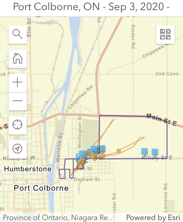
Port Colborne’s EF0 tornado (late evening) had a maximum wind speed 125 km/h, a path length of 1.1 km, and a maximum width of only 50 m. The tornado produced damage to some trees and houses.

The investigation map from NTP below shows the drone (orange) and the land (blue) survey paths. Click on the map to go to their site and view the photos.

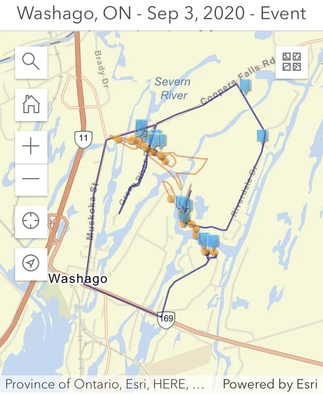
Washago’s EF1 tornado (evening) had maximum wind speed of 145 km/h, a path length of 1.85 km and a maximum width of 90 m. The tornado produced damage mainly to mature trees along a narrow path.

You can see the narrow path of the tornado in this video:

The investigation map from NTP below shows the drone (orange) and the land (blue) survey paths. Click on the map to go to their site and view the photos.


We sincerely hope everyone stayed safe in the path of these tornadoes and thank you so much to all of those who sent in reports! Your reports are critical in confirming tornadoes and continuing our goal to raise awareness about them and severe weather. Thank you!

Two More Tornadoes in Ontario; 2 EF1 Tornadoes on August 27 2020 Confirmed

The Northern Tornado Project team confirmed that two EF1 tornadoes occurred during the afternoon of August 27, 2020 in Southern Ontario.

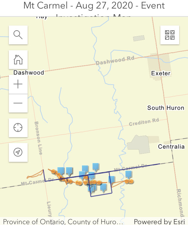
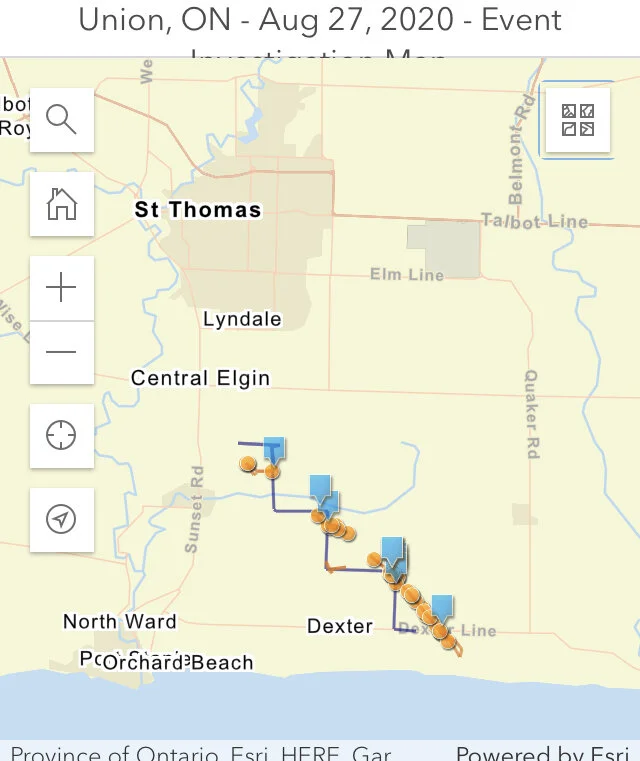
Their investigation of the tornado at Mount Carmel (2:30 PM) found that this tornado had a maximum wind speed of 155 km/h, 7.1 km long path with a width of 100m. The damage to the century barn can be seen in this tweet by Connell Miller from NTP:

A second tornado at Union (St. Thomas area) which occurred at 3:15 PM had a maximum wind speed of 150 km/h, 5.2 km long path with a width of 150m. They found that a small century barn was shifted on its foundation as well as damage to trees and crops. If you look closely you can also see crop damage in second photo in the tweet below:

NTP has information about their investigations including photos and maps showing the land (blue) and drone (orange) survey paths and where the photos were taken. Click on the maps below to go to their site and view the details.


Timeline

11:30 AM: Environment Canada issued a Severe Thunderstorm Watch that included both areas affected by the tornadoes:


1:29 PM: Environment Canada issued a Severe Thunderstorm Warning that includes Southern Huron County (Mount Carmel):


2:06 PM: Environment Canada issued a Severe Thunderstorm Warning for an area that included Eastern Lambton County (just south of Mount Carmel)


2:39 PM: Environment Canada issued a Severe Thunderstorm warning for the area that included St. Thomas (Union):


2:45 PM: Adam went live.


3:12 PM: We notified all those in the path who use our app, text service, and social media pages “Tornado Reported” for the area near St. Thomas (Union).


3:12 PM: At the same time Environment Canada also issued a Tornado Warning for the St Thomas (Union) area:


Keep alert and trust your intuition if you think that the weather may be severe. The Mount Carmel tornado did not have a tornado warning. There can be many reasons why some tornadoes are not warned. Different areas have different radar coverage and some tornadoes do not have a strong radar signature. Some tornadoes may also form quickly and the associated radar signature is brief. Observations by reliable spotters play a role in tornado warnings as well.

We sincerely hope everyone stayed safe in the path of these tornadoes and thank you so much to all of those who sent in reports! Your reports are critical in confirming tornadoes and continuing our goal to raise awareness about them and severe weather. Thank you!

Embed Block
Add an embed URL or code. Learn more

Ontario's 29th Tornado Of The Year; EF0 Tornado Confirmed From Friday At Point Clark, ON With 130km/h Maximum Estimated Winds

(Radar Image courtesy of enVironment canada)

(Radar Image courtesy of enVironment canada)

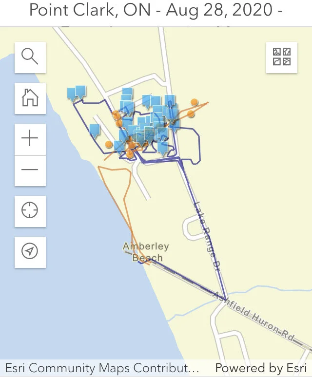
The Northern Tornado Project team has found damage consistent with a high-end EF0 tornado in Point Clark, Ontario. This tornado occurred at approximately 10:15 PM on Friday, August 28, 2020.  It adds to Ontario’s already very active tornado season being the 28th tornado in 2020 - more than double the average of 13! The estimated maximum wind speed was 130 km/h. They also found the path of the tornado to be 300 metres long with a maximum width of 80 metres. Note, the multiple directions that the trees fell which is a good indicator of a tornado:

You can also see the tree damage with the drone footage by Connell Miller:

Environment Canada also tweeted out this image showing radar images of the storm:

Mike Nailor shared some close up photos of the tree damage in the area:

The township sent out this news release the next day stating that significant damage had occurred:

The investigation map from NTP below shows the drone (orange) and the land (blue) survey paths. Click on the map to go to their site and view the photos.


Timeline

3:30 PM: We posted a heads up forecast that an isolated tornado was possible in the evening:

3:30 PM - Fri, Aug 28, 2020: Good afternoon! Keeping an eye on the potential for more strong thunderstorms later this...

Posted by Ontario Tornado Watch / Ontario Blizzard Watch on Friday, August 28, 2020

9:28 PM: Environment Canada issued a Severe Thunderstorm Watch:


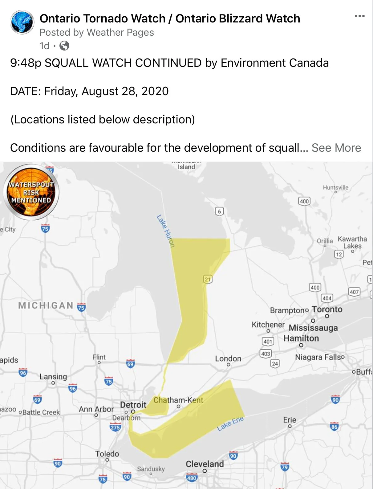
9:48 PM: Environment Canada issued a Squall Watch for Lake Huron mentioning waterspout potential.


9:51 PM: Environment Canada issued a Severe Thunderstorm Warning:


9:58 PM: With the help of Kevin Ramage, we notified all those in the path who use our app, text service, and social media pages “Minor Rotation Detected” and the potential of an isolated tornado:


10:05 PM: Environment Canada issued a Squall Warning for Lake Huron mentioning waterspout potential:


10:12 PM: Environment Canada upgraded the Severe Thunderstorm Warning to mention the potential of a tornado.


We sincerely hope everyone stayed safe in the path of this tornado and thank you so much to all of those who sent in reports! Your reports are critical in confirming tornadoes and continuing our goal to raise awareness about them and severe weather. Thank you!